• Welcome to TalkWeather!
    We see you lurking around TalkWeather! Take the extra step and join us today to view attachments, see less ads and maybe even join the discussion.
    CLICK TO JOIN TALKWEATHER
  • April 2024 Weather Video of the Month
    Post your nominations now!

Southeast Svr Wx threat April 8-11, 2024

wx_guy

Member
Messages
294
Reaction score
844
Location
United States
HAM Callsign
KO4ZGH
Special Affiliations
  1. SKYWARN® Volunteer
  2. ARRL Member
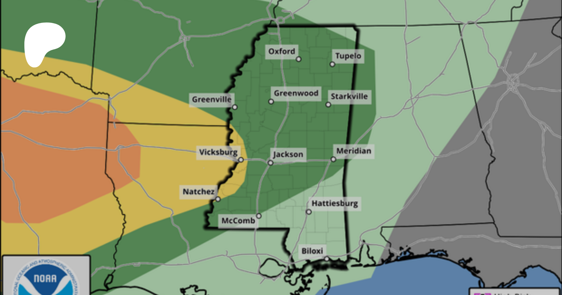
For what it's worth (I accidentally sampled the 12z NAM instead of 18z in the above post), the 18z NAM looks even worse in a bigger area. Really troubling parameters in Louisiana/Mississippi. I definitely feel that if the GFS or Euro coincide with this, the SPC will have to orange-ify the area tomorrow morning.
 

wx_guy

Member
Messages
294
Reaction score
844
Location
United States
HAM Callsign
KO4ZGH
Special Affiliations
  1. SKYWARN® Volunteer
  2. ARRL Member
The 06z NAM 3k high resolution CAM is now in focus for the Wednesday threat. The current solution shows a nasty complex of supercells across Mississippi Wednesday afternoon. This sounding shows very high kinematic fields for anything that can take advantage of it. EDIT: The LR at the surface look low, though, at 5.3 --- so if they stay that low, it may be difficult for storms to grow effectively...we'll see how this pans out in future model runs.

1712582642386.png
1712582680091.png


And for good measure, my ML program says:

1712582869101.png
 

KevinH

Member
Messages
1,878
Reaction score
3,039
Location
West Central GA
The 06z NAM 3k high resolution CAM is now in focus for the Wednesday threat. The current solution shows a nasty complex of supercells across Mississippi Wednesday afternoon. This sounding shows very high kinematic fields for anything that can take advantage of it. EDIT: The LR at the surface look low, though, at 5.3 --- so if they stay that low, it may be difficult for storms to grow effectively...we'll see how this pans out in future model runs.

View attachment 25197
View attachment 25198


And for good measure, my ML program says:

View attachment 25199
This looks kind of messy.
 

wx_guy

Member
Messages
294
Reaction score
844
Location
United States
HAM Callsign
KO4ZGH
Special Affiliations
  1. SKYWARN® Volunteer
  2. ARRL Member
This looks kind of messy.
Yeah, and with the lower Lapse Rates around 5 (depicted in the sounding I clicked above), it may have good parameters but wind up as a mess of a complex of rain shield and thunder-lightning and not much else. Have to see how the future CAM runs go.
 
Messages
2,903
Reaction score
4,809
Location
Madison, WI
We've seen mediocre/poor low-level lapse rates sink a couple of Southern setups with strong low-level shear already this year. Definitely a tricky forecast because if something does take off, it could take off big.

It can be an abrupt transformation, too when storms finally do (if they do) hit that sweet spot of favorable low-level thermodynamics. Last July 12th I was following that messy little cell for over an hour while it struggled and I was seriously tempted to just start going home; then suddenly it was producing tornadoes. Or, they could just continue to struggle the entire period.
 
Last edited:

wx_guy

Member
Messages
294
Reaction score
844
Location
United States
HAM Callsign
KO4ZGH
Special Affiliations
  1. SKYWARN® Volunteer
  2. ARRL Member
Aaaand with the 12z NAM 3k CAM, the plot thickens further. Here's the setup depicted at 5 PM CDT. The mass of rain at 18z splinters into discrete supercells ahead of the main line. However, the low-level Lapse Rates in western AL average between 4.8 C/km and 5.0 C/km, which would probably put a damper on things.

Further west, messy convection tries to form ahead of the main line -- whether that's successful or not is too soon to say (the model only goes out to 60 hours), but the parameter space is more conducive here, except for those pesky low-level Lapse Rates. If the storms can overcome the LR, southern MS and eastern LA are "PDS TOR" Hazard types (please take hazard type with a huuuuuuge grain of salt - it's convenient but is overused and misused by too many amateurs. I'll avoid the soapbox atm, but yeah). Of course, it's all speculation atm, but that's what we do haha

1712588607933.png
 

JBishopwx

Member
Sustaining Member
Messages
940
Reaction score
2,139
Location
Ackerman, MS
Special Affiliations
  1. SKYWARN® Volunteer
Jackson has a good discussion

Severe storms: There will be some favorable ingredients Tue night,but feel there will be limitations and only expect isolated severestorms if that can get going. Severe focus will be for Wed. Thiscould get an early start or it could be delayed a tad and more inline with afternoon heating. It will all depend on the location ofthe boundary and if enough capping exists due to slower ascent fromthe large scale system. Current Enhanced outlook from SPC is thebest course at this time. If the boundary holds more W/NW then thatopens the door for more of the forecast area to be in the warmsector and with strong forcing and a deepening surface low approaching,it could be more of a widespread wind event from an MCS with asolid tornado threat. Again, this is a scenario with a slowerevolution and more W/NW early boundary. Now, another scenario,which has solid support, is that the boundary moves more south andearlier due to the heavy/flooding type precip Tue night. If thisplays out, then the warm sector is smaller and more south. Thiswould result is the severe focus more in our S part of theforecast area or even more south out of the area. I do think ourSE is in the Svr mix either way. All that said, each of thosescenarios has quite the differences in much much/who in our areawill be (if at all) impacted by severe storms. I wanted to coverthis as to note there`s still varying solutions in the cards onoverall impact/intensity
 
Messages
2,903
Reaction score
4,809
Location
Madison, WI
I haven't been paying that close attention but it seems robust supercells have thus far struggled to become established for today/tonight's portion of the event. No tornado reports across WW 90/92 and not even any tornado warnings each time I've pulled up GR Level 3.

We'll see if those updrafts around Stephenville, TX amount to anything but it could be too little, too late with the loss of daytime heating. Seems the strongest storms attm are the bow echo west of Haskell and the northward moving hailer in the northern DFW suburbs.
 
Last edited:

wx_guy

Member
Messages
294
Reaction score
844
Location
United States
HAM Callsign
KO4ZGH
Special Affiliations
  1. SKYWARN® Volunteer
  2. ARRL Member
The 0z HRRR paints a much more limited outbreak on Wednesday, with the threat confined to within 100-150 miles of the LA, MS, AL, and FL coast. The 3k NAM 0z is coming in now, it'll be interesting to see what it says.

1712628001307.png
 

UK_EF4

Member
Messages
573
Reaction score
1,329
Location
NW London
Good googly moogly they pulled the trigger on a moderate tornado risk lol
Can definitely see where they are coming from. QLCS tornadoes with sufficient CAPE and very strong shear can produce a lot of tornadoes, including strong ones - Easter 2020, March 2022, April 4-5 2022 just some quick examples that come to mind. Not so sure on the potential for any semi-discrete supercells ahead of the line, but if they do occur they would have an intense tornado threat too.
 
Back
Top