TileDude
Member

Follow along with the video below to see how to install our site as a web app on your home screen.

Note: this_feature_currently_requires_accessing_site_using_safari

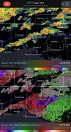
ooooo I wonder if the SPC will issue a special D2 outlook given the threats cross the 7am cut off timeFrom Spann:
MAJOR FORECAST CHANGE: Originally the forecast was for strong to severe thunderstorms across Alabama tomorrow afternoon/evening. But, based on current observations and high resolution model trends, some wholesale changes need to be made.
*It now looks like the threat of strong to severe thunderstorms will come after midnight tonight, in the general time frame from 1 am until 12 noon Sunday.
*The main threat initially will come from strong gusty winds after midnight across North Alabama. As the line of storms encounters better instability over the southern half of the state, an isolated tornado is possible mainly south of I-20 after 6:00 a.m.
*The risk of severe thunderstorms tomorrow afternoon will be mainly over the southern third of the state, south of U.S. 80.
Be sure you have a reliable way of hearing a warning in the middle of the night in the event they are needed (a NOAA Weather Radio is the best choice).
I understand this is not in line with the current SPC forecast; but it is in agreement with latest thinking from NWS Birmingham. Weather in March can be complex here, and the forecast can change like this. I will post more notes later this evening.

That event underperformed but it spawned an F3 that was originally F4 and in all honesty probably shouldn't have been downgraded.looks like it will be about another week n half to two weeks before see pattern shift into a better severe weather setup for most on this board. still like end of this month going into the month of april. buckle up .one analog year got my attention for month of april was , april 2006... there was a event that put out a 60 percent signature for tornadoes for mid outh and tennessese valley ...
yeah that event was a keg of dynamite waiting to explode... it did get going pretty good other side of tennessee riverThat event underperformed but it spawned an F3 that was originally F4 and in all honesty probably shouldn't have been downgraded.
I'll take the break! Any break is good for this active start of the yearlooks like it will be about another week n half to two weeks before see pattern shift into a better severe weather setup for most on this board. still like end of this month going into the month of april. buckle up .one analog year got my attention for month of april was , april 2006... there was a event that put out a 60 percent signature for tornadoes for mid outh and tennessese valley ...