• Welcome to TalkWeather!
    We see you lurking around TalkWeather! Take the extra step and join us today to view attachments, see less ads and maybe even join the discussion.
    CLICK TO JOIN TALKWEATHER

Volcano thread

bjdeming

Member
Sustaining Member
Messages
1,600
Reaction score
1,317
Location
Corvallis, Oregon
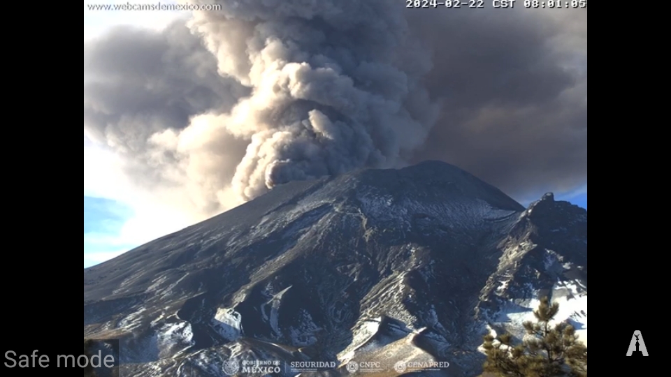
Just to keep everyone confused, the similarly named MErapi, over on Java, is having more energetic activity, too. (Fortunately, that's within typical limits in its ongoing eruption -- Merapi typically blows its top every 100 years or so, last in 2010 -- and no one ever goes onto the active pyroclastic flow fields when this Decade Volcano is active, which is most of the time, at a relatively low level.)

This video shows the roiling clouds of one of the series of flows this morning. It was tweeted about three hours ago. The perspective is as though we're looking over Merapi's shoulder at the action going on beyond that peak:


Otherwise, no more news on the tragedy at MArapi (on Sumatra) seems available in English online at the moment.
 

bjdeming

Member
Sustaining Member
Messages
1,600
Reaction score
1,317
Location
Corvallis, Oregon
Got back online and found this excellent thread from a lay reliable source (Twitter will translate it):


bjdeming

Member
Sustaining Member
Messages
1,600
Reaction score
1,317
Location
Corvallis, Oregon
Tweeted about four hours ago. This is just a layperson opinion, but uptick in sulfur dioxide is one of the common precursors of eruption; it comes from magma near the surface. To my very amateur mind, this seems to suggest that it was a phreatic explosion (see the tweet in the last post), which can happen without warning, and once that blast opened the system, whatever SO2 happened to be in there flowed out:


bjdeming

Member
Sustaining Member
Messages
1,600
Reaction score
1,317
Location
Corvallis, Oregon
Meanwhile, in Hawaii a couple of moderate-sized quakes have happened near Kilauea's summit, though it isn't erupting at the moment and has had just short-lived caldera eruptions recently.

HVO's update today covers that. It's also interesting what they say about inflation:

HAWAIIAN VOLCANO OBSERVATORY DAILY UPDATE
U.S. Geological Survey
Thursday, December 7, 2023, 8:06 AM HST (Thursday, December 7, 2023, 18:06 UTC)


KILAUEA
(VNUM #332010)
19°25'16" N 155°17'13" W, Summit Elevation 4091 ft (1247 m)
Current Volcano Alert Level: ADVISORY
Current Aviation Color Code: YELLOW


Activity Summary:  Kīlauea volcano is not erupting. Last night saw moderate seismicity in the summit region, with continued low-level seismic activity in the upper East Rift Zone and Southwest Rift Zone over the past day. Unrest may continue to wax and wane with fluctuating input of magma to the area, and eruptive activity could occur in the near future with little or no warning. No unusual activity has been noted along the middle and lower sections of Kīlauea’s East Rift Zone.

Summit Observations:  Summit seismicity experienced a slight uptick last night, focused in the area south of Kīlauea's summit caldera. This followed several days of relatively low seismicity, but activity did not reach the levels seen during an earthquake swarm on December 2, nor the levels that immediately preceded recent summit eruptions. A M4.4 earthquake occurred east-northeast of the summit at 5:17 p.m. HST yesterday at a depth of 14 mi (23 km), and a M3.6 earthquake occurred east-northeast of Pāhala at 7:13 a.m. HST today at a depth of 21 mi (33 km); neither of these earthquakes are believed to be directly related to near-surface volcanic activity, and no associated changes were observed at Kīlauea.

The Uēkahuna summit tiltmeter—located northwest of the caldera—tracked steady inflationary tilt until around midnight last night, when there was a quick transition to deflationary tilt. Despite a brief interruption between 5:00 a.m. and 7:00 a.m. HST this morning, the deflationary trend continues at this time. The Sand Hill tiltmeter—located southwest of the caldera—has tracked similar trends. Overall, the summit of Kīlauea remains at a high level of inflation; relative tilt is above the level reached prior to the most recent eruption in September 2023, and it is higher than at any time since the 2018 eruption.

Sulfur dioxide (SO2) gas emission rates remain low. Field measurements indicated an SO2 emission rate of approximately 70 tonnes per day on December 5, which was similar to measurements in October and November.

There are currently no signs of an imminent eruption, but the summit region remains unsettled, with a high level of inflation and moderate seismic activity. The onsets of previous summit eruptions have been marked by strong swarms of earthquakes caused by the emplacement of a dike 1–2 hours before the appearance of lava, and these swarms are not being detected at this time.

The HVO information statement released on October 23, 2023, provides additional information and context related to recent unrest at Kīlauea's
summit: https://volcanoes.usgs.gov/hans2/view/notice/DOI-USGS-HVO-2023-10-23T22:33:18-07:00

A map summarizing recent unrest southwest of Kilauea’s summit (activity beginning October 4, 2023) can be found here: https://www.usgs.gov/maps/november-5-2023-summary-map-intrusive-activity-kilauea-volcano

Rift Zone Observations:  Small earthquakes (less than M2.0) have continued to occur in the upper East Rift Zone following a swarm early on December 2, with steady activity over the past day. Earthquakes continue in the Southwest Rift Zone as well, but at a diminished rate compared to a few weeks ago.

We continue to closely monitor both rift zones, especially near the summit. No unusual activity has been noted along the middle and lower East Rift Zones. Measurements from continuous gas monitoring stations downwind of Puʻuʻōʻō in the middle East Rift Zone—the site of 1983–2018 eruptive activity—have been below detection limits for SO2, indicating that SO2 emissions from Puʻuʻōʻō are negligible.

Hazard Analysis:  Levels of volcanic gases (sulfur dioxide and carbon dioxide) can remain locally hazardous even when Kīlauea is not erupting. Local concentrations of sulfur dioxide (SO2) and/or hydrogen sulfide (H2S) may persist in downwind areas, and residents may notice odors of these gases occasionally. Significant hazards also remain around Halemaʻumaʻu from crater wall instability, ground cracking, and rockfalls that can be enhanced by earthquakes within the area closed to the public. For discussion of Kīlauea hazards, please see: https://www.usgs.gov/observatories/hawaiian-volcano-observatory/hazards.

The Hawaiian Volcano Observatory (HVO) continues to closely monitor Kīlauea volcano.

Next Notice: HVO will issue daily Kīlauea updates. Additional messages will be issued as needed.

Inflation/deflation events here are studied intensively, as this abstract written three years before the 2018 eruption shows.
 

bjdeming

Member
Sustaining Member
Messages
1,600
Reaction score
1,317
Location
Corvallis, Oregon
Some local "chasers" are discussing this Kilauea situation now (their text on the You Tube page sums things up, too):


Some of these folks stood out on the Saddle Road one night last year, in the rain, sharing live video of Mauna Loa's lava flows coming down nearby. ♥️

FWIW, I voted for after December 31st in their poll, figuring that DI events are still ongoing and as they say, Kilauea seems compensated just now.

It's a really complex picture overall, though, one that also involves Mauna Loa (which is why they talk about that, too) and perhaps even the new seamount/future Hawaiian Island off Pahala a ways.
 

bjdeming

Member
Sustaining Member
Messages
1,600
Reaction score
1,317
Location
Corvallis, Oregon
Rain-wrapped volcano:


Relax. It's MErapi (Java) and this unmanned station is quite close to these uninhabited "Merapi-style" flow fields.
 

bjdeming

Member
Sustaining Member
Messages
1,600
Reaction score
1,317
Location
Corvallis, Oregon
Per the Global Volcanism Program:

According to ReliefWeb, the U.S. Agency for International Development (USAID) reported that the 20 November eruption at Ulawun resulted in five deaths and the evacuation of more than 16,000 people, with many more affected, as of 9 December. Ashfall from the eruption impacted oil palm trees, water sources, household gardens, and nearby properties.


Source: ReliefWeb
 

bjdeming

Member
Sustaining Member
Messages
1,600
Reaction score
1,317
Location
Corvallis, Oregon
Meanwhile, in Mexico...

...Under this series of events, the authorities of the United States Agency for International Development ( USAID ) announced, through their social networks, that they entered into an alliance with the Disaster Assistance Program (VDAP) of the US Geological Survey ( USGS ) and the National Center for Disaster Prevention ( Cenapred ).

This is intended to improve monitoring of the Michoacán-Guanajuato volcanic field and thus “protect communities around the world from volcanic threats.”

In this way, they will seek to advance the global risk mitigation capacity to save lives.

Does it mean the birth of a volcano?​

There has been much speculation about the possible birth of a volcano taking into account the proximity of volcanoes, such as Paricutin or Tancítaro. However, recent analyzes carried out by the National Seismological Service, based on the distribution of hypocenters and focal mechanisms (to characterize the seismic source or type of fault that gave rise to the earthquake), attribute the recent seismicity to a fault system called “ Graben Peribán - Los Reyes” ( see publication ), a graben is a tectonic graben formed by a pair of normal faults, produced by tectonic expansion efforts.


pic


Image : Map of the National Seismological Service showing the distribution of epicenters of the seismic sequence from May 15 to 21, 2023. The focal mechanism or “beach ball” is also shown for M4.6, corresponding to a type fault. normal, associated with the Peribán-Los Reyes Graben.

The presence of seismicity, in some cases, is usually the most precursory activity that indicates new magma intrusions in a region. However, there are other indicators that can help confirm or rule out said volcanic reactivation such as soil deformation, changes in the chemical composition in the springs, rivers/streams in the area, emanation of volcanic gases in some specific points in the region, among other. It should be noted that none of these indicators have been presented so far or there is no public data to demonstrate this...

Source (autotranslated)

I saw the USAID tweet but didn't have time to look into the complex situation.

Here's the USGS page on VDAP.
 

bjdeming

Member
Sustaining Member
Messages
1,600
Reaction score
1,317
Location
Corvallis, Oregon
Unlike land eruptions on the Reykjanes Peninsula, Grimsvötn's eruption, if this leads up to one, would be explosive, because it sits underneath ice, and it would affect air travel to some degree.

However, they say that eruption risk is only slightly increased and they only went up to Yellow again today:

VONA message​


Grímsvötn​


Time: 11. Jan 2024, 12:17 GMT


Color code: Yellow


Volcano id: 373010


Activity summary:
This morning at 06:53, a magnitude 4.3 earthquake occurred in Grímsvötn. This is the largest earthquake in Grímsvötn since the beginning of measurements in 1991. In recent days, a slow and gradual increase in tremor has been detected on Grímsfjall, and the water level in Gígjukvísl has been increasing since yesterday night. Therefore, a glacial flood (jökulhlaup) has started from Grímsvötn. It is likely that the earthquake this morning is due to pressure release following the onset of the glacial flood.Due to the ongoing flood and increase in seismicity the aviation color code for Grímsvötn volcano is raised to yellow as the likelihood of an eruption has slightly increased.


Cloud height:
NA


Other cloud information:
NA


Remarks:
There are past examples of Grímsvötn eruptions starting, following a flood. The drainage of the water from Grímsvötn lake reduces the pressure on top of the volcano and this can result in an eruption. This happened in 2004, and before that in 1934 and in 1922. However, twelve glacial floods have occurred since 2004 without triggering an eruption. Seismicity over the past 4 months has been above background.

-- Source

There is also some seismicity from nearby ice- capped Bardarbunga, host of the 2014-2015 Holuhraun eruption (voluminous but not explosive because it occurred along fissures at some distance from the ice-topped caldera, which collapsed). IMO expresses no concern about a Bardarbunga eruption.
 

bjdeming

Member
Sustaining Member
Messages
1,600
Reaction score
1,317
Location
Corvallis, Oregon
AFAIK, none of these five volcanoes, erupting now or on alert as some are, teeters on the edge of sudden explosiveness or other abrupt hazard, and AVO is renowned for their ability to monitor through the indirect methods they mention, but it will be good when they can get the network back up.


bjdeming

Member
Sustaining Member
Messages
1,600
Reaction score
1,317
Location
Corvallis, Oregon
Indonesia's MErapi (Java) had a spectacular set of pyroclastic flows today that made headlines --


but volcanologists report (Indonesian) that the runout was 1.5 km -- within typical range for ongoing activity.

Sure is messy for the neighborhood and for aviation, though.


This is no 2010-like tantrum, fortunately.
 

bjdeming

Member
Sustaining Member
Messages
1,600
Reaction score
1,317
Location
Corvallis, Oregon
Per IMO (autotranslated), the alert status on old Gray Water (Grimsvötn) is lowered back down -- for now

[QUOTE[
When the glacier retreat began, the flight color code for the volcano was changed to yellow because there was an increased chance of an eruption following a pressure relief after water flowed from Grímsvatten. Since the glacier run has ended and no short-term changes in activity have been observed, the flight color code will be changed back to green.

In the long term, however, there has been some activity in Grímsvatn, and in the last five months, the number of earthquakes has exceeded the number that is considered normal background activity. If there were to be a volcanic eruption in Grímsvatten, it is expected that intense increases in small seismic activity would be noticed before an eruption began. Scientists from the Norwegian Meteorological Agency and the Earth Sciences Institute will continue to monitor Grímsvatten very closely and share information if activity increases further. [/QUOTE]
 

bjdeming

Member
Sustaining Member
Messages
1,600
Reaction score
1,317
Location
Corvallis, Oregon
This is time sensitive but spectacular, if anyone wants to watch right now -- the moon is descending directly over Popocatépetl summit (which is smoking but the plume is kept low by strong winds) and the sun will soon be rising (left) to add adobe rose, yellow, and orange to the scene:


bjdeming

Member
Sustaining Member
Messages
1,600
Reaction score
1,317
Location
Corvallis, Oregon
Sorry -- I have no video editing skills yet but can press a screen-record button. Feel free to speed up or enlarge this, if you want. (Since it was mobile, I stopped recording soon after moonset.)


They did a good job adjusting the tricky lighting -- at times, you can even see lava incandescence on the crater plume!

As for wind speed, all I know is that the summit tops out just shy of 18,000 feet at the moment.
 

bjdeming

Member
Sustaining Member
Messages
1,600
Reaction score
1,317
Location
Corvallis, Oregon
And they're back online, with no intervening crises. :)


bjdeming

Member
Sustaining Member
Messages
1,600
Reaction score
1,317
Location
Corvallis, Oregon
Kilauea might be getting set to go off again either in or just outside the summit caldera (no changes have been reported along the lower rift zones where people live). The USGS just put up an interesting summary of the unrest. (The upper SW rift zone cam is focused on the possible extracaldera eruption site.)
Actually, it "just" did a bunch of interesting stuff below the surface. Anyone near its southwest rift zone is probably watching it closely.

For details:

Volcano Watch — Another intrusion southwest of Kīlauea’s summit

February 8, 2024

Volcano Watch is a weekly article and activity update written by U.S. Geological Survey Hawaiian Volcano Observatory scientists and affiliates.
 
Last edited:

bjdeming

Member
Sustaining Member
Messages
1,600
Reaction score
1,317
Location
Corvallis, Oregon
My favorite volcano is getting its plume on at the moment and Mexico City might get a slight dusting, but this is well within expected activity for the current Yellow Phase 2 alert.

Updated link:


NOAA OSPO page

CENAPED post, Feb. 21 (autotranslated)
 
Last edited:

bjdeming

Member
Sustaining Member
Messages
1,600
Reaction score
1,317
Location
Corvallis, Oregon
Update:

It looks like end times on the Tlamacas cam --

screenshot_20240222-055922_youtube.jpg


-- but no, just ¡happy Thursday!


CENAPRED did do a 5 p.m. update yesterday, in addition to the usual one at 11 a.m., but there were no alert level changes. There is nothing new on their website now, either.

Popo does this now and again, but this level of activity only is an ash nuisance.
 

bjdeming

Member
Sustaining Member
Messages
1,600
Reaction score
1,317
Location
Corvallis, Oregon
Popocatepetl is working hard but the ash stream is horizontal thus far as this tweet from a former CENAPRED director and Popocatepetl admirer, based in Mexico City, shows:


This volcano is capable of plinian activity, but the constant degassing seems to have reduced explosivity in a major way. :)

Of course, that raises the question of what is making it vent so much of the stuff now. There hasn't been a major shift in deformation reported recently, AFAIK (which isn't far).

That tweet was posted half an hour ago. Last night at 1830 local time CENAPRED did an update on ashfall, which covered a considerable area -- a damaging material and a health hazard -- but the status is still Yellow, Phase 2.

Per cams, both cities west and east of the volcano, Mexico City and Puebla, respectively, have some ash, but the bulk of it is heading north right now.
 
Last edited:
Logo 468x120
Back
Top