- Thread starter
- Moderator
- #41
Navigation
Install the app
How to install the app on iOS
Follow along with the video below to see how to install our site as a web app on your home screen.

Note: this_feature_currently_requires_accessing_site_using_safari
More options
-
Welcome to TalkWeather! We see you lurking around TalkWeather! Take the extra step and join us today to view attachments, see less ads and maybe even join the discussion. CLICK TO JOIN TALKWEATHER -
 April 2024 Weather Video of the Month Post your nominations now!
You are using an out of date browser. It may not display this or other websites correctly.
You should upgrade or use an alternative browser.
You should upgrade or use an alternative browser.
Severe Weather Threat - June 11th-15th, 2023
- Thread starter Taylor Campbell
- Start date
JPWX
Member
Clancy
Member
Equus
Member
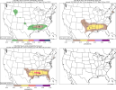
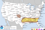
Feels like we may be going enhanced tomorrow on D1 honestly, that would be quite a stretch of enhanced days in June in the southern states
Clancy
Member
Severe Thunderstorm watch for parts of the Gulf Coast.


Storm Prediction Center Severe Thunderstorm Watch 275
Severe weather, tornado, thunderstorm, fire weather, storm report, tornado watch, severe thunderstorm watch, mesoscale discussion, convective outlook products from the Storm Prediction Center.
www.spc.noaa.gov
OHWX97
Member
ILN has confirmed two EF0's near Tipp City and Christiansburg, OH from last night's storms. No word yet on the tornadoes near Mount Orab and Lynchburg.
Clancy
Member
JPWX
Member
I got 191 lightning shots off the GoPro 11 just from last night off a total of 3 videos. The lightning was constant with the Northeast MS storms.
Clancy
Member
JPWX
Member
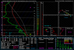
DANG! That's the highest STP and Supercell Parameter I've seen this far south outside of the usual Tornado Alley areas plus in June. Of all things23Z Wednesday south of BMX. Off the 3km NAM.
View attachment 20516
Clancy
Member
Caveat of it probably being mostly CAPE-driven, but still a concerning look.DANG! That's the highest STP and Supercell Parameter I've seen this far south outside of the usual Tornado Alley areas plus in June. Of all things
Clancy
Member
- Moderator
- #55
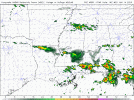
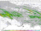
Also HRRR showing UH streaks across N AL into GA.
View attachment 20517
That large red streak in North AL is right over my house. Me no likey.
OHWX97
Member
Nadocast, I’m gonna have to ask you to chill out. Please and thank you.
keithGA
Member
Nadocast, I’m gonna have to ask you to chill out. Please and thank you.
Did we time travel back to March/April or something? Sheesh.
- Thread starter
- Moderator
- #58
A well written AFD from BMX. A very active period ahead. Stay safe you all.
000
FXUS64 KBMX 131056
AFDBMX
Area Forecast Discussion
National Weather Service Birmingham AL
556 AM CDT Tue Jun 13 2023
...New AVIATION...
.SHORT TERM...
(Today through Wednesday Night)
Issued at 347 AM CDT TUE JUN 13 2023
* Active weather is expected through the next 48 hours with multiple
waves of showers and thunderstorms impacting Central Alabama.
Severe thunderstorms will are likely at times, as well as locally
heavy rainfall which could lead to flash flooding. Stay tuned to
the forecast and refer to our homepage at weather.gov/bmx for the
latest impact graphics.
Today and Tonight.
Latest mesoanalysis depicts the presence of the subtropical jet
stretched across the Southern Plains and Southeast, with low
amplitude cyclonic curvature around a large area of low pressure
across the Great Lakes. A low amplitude ridge is situated across the
Central and Southern Plains. 500 mb flow is ~50 kts per mesoanalysis
and our 13/00z RAOB.
As advertised the past few days, multiple impulses will be moving
across the Deep South, embedded within the westerly flow aloft. (As
many as 4 could occur through Wednesday night). The introductory
impulse is progged to arrive later this morning and into the
afternoon. This will help tug moist, unstable boundary layer
conditions northward from its current resting position across the
Gulf Coast, likely getting into our southern forecast area by the
afternoon. The impulse will foster shower and embedded thunderstorm
development from the west, with stronger convection favoring areas
south where greatest MUCAPE will reside. Various models suggest
<3,500 MUCAPE with 40-50 kts eff. bulk shear, with modest mid-level
lapse rates (6.0-6.5 C/km). A few strong/severe thunderstorms will
be possible across the south as a result. Large hail and damaging
wind gusts will be the main threats with strongest (rotating)
updrafts.
After a brief lull in activity this evening, a subsequent impulse is
progged to move in from the west, slightly farther north in latitude
and arguably more potent. This will coincide with a strengthening
low-level jet extending north into Central Alabama resulting in a
confluence axis near the I-20 corridor. As such, nocturnal
thunderstorms are expected to initiate with similar thermodynamic &
kinematic parameters as mentioned before. With forcing better
focused along the front/low-level confluence axis, I suspect greater
thunderstorm coverage than during the afternoon, with strongest
thunderstorms producing large hail and damaging wind gusts.
Steepening lapse rates aloft suggest the overnight threat could
contain significant hail. Westerly flow atop the west-to-east
oriented boundary suggests training thunderstorms could also occur.
If this is the case, flash flooding could be expected due to high
rainfall rates, some of which could impact our urban areas.
Wednesday and Wednesday night.
I`d say the most potent impulse is set to arrive across the Deep
South on Wednesday. This has been the case for a few days now with
several models indicating the best parameter space as well. Latest
CAM guidance suggests lingering convection from Tuesday night
persisting into Wednesday morning, with additional development
possible into the early afternoon, but with southeastward
progression into Georgia. These storms will continue to carry a
threat for large (possibly significant hail), as well as damaging
winds and flash flooding. However, low-level flow will continue
advect moist, unstable air into the area late Wednesday afternoon
and evening when the 3rd impulse is set to arrive. The airmass in
place can be characterized by MUCAPE <4,500 J/kg with 50-55 kts eff.
bulk shear. Given available forcing and deep boundary layer
moisture, rapid updraft intensification will be possible with
scattered to numerous supercells developing across Central MS and
AL. These thunderstorms will carry a threat for large, damaging
hail, potentially up to baseball size, as well as damaging wind
gusts, before growing upscale.
A non-zero tornado threat will also exist across our southern
counties as 20-30 kt 850 mb flow becomes more southwesterly (south
of the boundary), broadening hodographs and increasing 0-1 km SRH to
<200 m2/s2. I do believe this threat will be spatially & temporally
limited and contingent upon the right storm-scale evolution near
the boundary.
Initial supercell storm modes should grow upscale into a more
linearly organized MCS, with embedded supercells. This will begin to
foster a greater damaging wind threat, with additional flash
flooding occurring with any training thunderstorms. Total rainfall
amounts up to 5" could occur for some locations, today through
Thursday morning.
40/Sizemore
- Thread starter
- Moderator
- #59
&&
.LONG TERM...
(Thursday through Monday)
Issued at 347 AM CDT TUE JUN 13 2023
/Active stretch of weather goes on/
Similar to the day prior, a surface boundary is expected to be
draped across the Gulf Coast region on Thursday. The synoptic
pattern will maintain a plume of seasonably strong 500mb flow
across our region. Forecast models indicate additional storms
forming in the vicinity of the surface boundary through the day;
however, there are differences regarding the latitudinal placement
of the boundary, which will guide subsequent severe storm
prospects given moderate to strong instability and bulk shear near
45 knots along and south of the boundary. The environment, along
with aid from a subtle shortwave within the mean flow, could
support storms capable of severe gusts and large hail. Right now,
the risk for severe storms generally favors the southern portion
of Central Alabama but adjustments to the placement of this risk
may be necessary as we get closer to Thursday. Training convection
may occur as well and, if this were to occur atop heavy rain
swaths from activity Tuesday-Wednesday, a flood risk could arise.
West-northwesterly to northwesterly continues through the weekend
with the GFS and ECMWF showing bouts of convective clusters
forming upstream of Alabama. Such activity should follow the
instability and shear gradient, which could favor a trajectory
toward our region. Of course, intra- and intermodel variability is
high in this sort of weather pattern including the development,
path, and maintenance of storm clusters. Other showers and storms
could develop locally given the warm and humid air mass.
89^GSatterwhite
KevinH
Member
AAAAAAAND this thread now has my attention for today but mostly tomorrow
What month is it again? SMH
What month is it again? SMH

