• Welcome to TalkWeather!
    We see you lurking around TalkWeather! Take the extra step and join us today to view attachments, see less ads and maybe even join the discussion.
    CLICK TO JOIN TALKWEATHER

Iceland's Fagradalsfjall Fires

bjdeming

Member
Sustaining Member
Messages
1,602
Reaction score
1,318
Location
Corvallis, Oregon
Nice orienting satellite view today. There's the power plant/barrier complex encirclement and there's Grindavik's more inverted-V system towards the bottom.


Will the northward flow head over earlier lava flows away from people or will it angle more westward? News interviews with IMO spokespeople mention some concern about that latter possibility eventually maybe but state that it's too early to tell right now.
 

bjdeming

Member
Sustaining Member
Messages
1,602
Reaction score
1,318
Location
Corvallis, Oregon
Still no word on the meeting that was reportedly scheduled for this morning, and no update yet on the IMO page.

Benedikt told Morning Paper (autotranslated) that landrise has picked up a bit though is not yet as fast as it has been in the past. He thinks it could be inertia or possibly more inflow.

Given the impressive bubbling seen on cams, this layperson's vote is for inflow -- the arrival of magma from depth that hasn't degassed much yet and now is doing so with a vengeance.

But IMO will probably issue a statement later this afternoon.
 

bjdeming

Member
Sustaining Member
Messages
1,602
Reaction score
1,318
Location
Corvallis, Oregon
Well, here is the 4 p.m. update (autotranslated):

Updated April 8 at 16:10


  • The eruption continues. One crater active.
  • Land has risen in Svartsengi by about 2-3 cm from 2.-7. April
  • Little gas pollution has been observed over the weekend, but temporarily high levels of sulfur dioxide can still be observed around the volcanic eruption and in settlements on the Reykjanes Peninsula. Advise people in the area to monitor air quality.
  • Today's weather forecast is for a north-easterly direction, and the gas pollution will therefore reach the south-west, incl. over Grindavík. An easterly direction tomorrow and then you can expect gas pollution west of the eruption centers. Gas distribution forecast here .

The eruption at the Sundhnúks crater series continues and now one crater is active. Lava flow from the crater flowed in a southerly direction yesterday in a rather limited stream, which became an impressive lava river. At the same time, the magma surface in the crater gradually rose until it was almost full. The northern rim of the crater broke at 21:30 last night so magma started flowing in the north direction. Today, April 8, you can see that the lava flow has mostly started to flow to the south again, but the advance of magma that we saw last night and night to the north, seems to have piled up there on the hill. The crater rim continues to charge up.


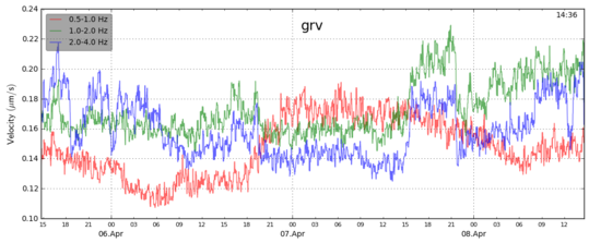
Lava flows are detectable on turbulence measurements of 1 to 2 Hz. (green frequency on graph) when the lava flow from the crater is at its greatest, the turbulence increases in parallel. After the rim of the crater gave way, you can see that the turbulence subsides again. Comparable turbulence activity was also seen in volcanic eruptions in Geldinga Valley, where turbulence increased as the lava flow increased.


Grv08042024oroi

Landris has increased somewhat in Svartsengi, but based on GPS measurements and satellite images, land has risen by 2-3 cm from 2.-7. April, which is, however, less than what was measured after the previous eruption in the last months. An increase in land could be a sign that magma flow has increased into Svartsengi or that the flow of magma from the eruption has slowed down.


A small amount of gas pollution has been detected on the gas meters of the UST Environment Agency and the Norwegian Meteorological Agency over the weekend, but temporarily high levels of sulfur dioxide can still be measured around the eruption and in settlements on the Reykjaness Peninsula. We advise people in the area to monitor air quality on the Environmental Agency's website .


Today's weather forecast is for a north-easterly direction, and the gas pollution therefore reaches the south-west, including over Grindavík. An easterly direction tomorrow and then you can expect gas pollution west of the eruption centers. The latest gas distribution forecast can be found here .

I guess they're saying that the plumbing might have clogged up, leading to that overflow yesterday as well as the ~1-inch rise of the Svartsengi plain in five days, or that it might be due to influx of more magma.

I have seen nothing recent about the lava barriers -- Iceland's headline news is dominated by a political crisis right now --- and wonder how they fared as that lava river went south.

The only other short-term potential human impact is the toxic gas that is forecast to head west toward the Blue Lagoon tomorrow.

From earlier news stories, the boffins are going to do some measurements this week to compare with last week's and try to quantify possible changes in the eruption.
 

bjdeming

Member
Sustaining Member
Messages
1,602
Reaction score
1,318
Location
Corvallis, Oregon
Isak managed to get an amazing eclipse shot:


Meanwhile, there isn't much news. The lava reportedly tends to head south but mostly ponds near the vent (i.e., piles up), which shows up nicely in this cam view from Thorbjorn:


On the Hagafell cam, a closer view suggests that the lava level might be rising again, but there is no lavafall yet and no confirmation of it from more knowledgeable sources (for scale, a few days ago that crater was said to be as tall as a five-story house, which might really mean six if Iceland follows the UK practice):


bjdeming

Member
Sustaining Member
Messages
1,602
Reaction score
1,318
Location
Corvallis, Oregon


Eruptions like this form sometimes firm lava tubes, which will affect the thermal output until the molten stuff exits and brightens up on imagery again.
 

bjdeming

Member
Sustaining Member
Messages
1,602
Reaction score
1,318
Location
Corvallis, Oregon
I went back and looked an hour or so later, and what had been a big thick flow was crusted over and the crater lava lake appeared lower -- just a momentary increase, probably.

And now IMO's update notes that the flow from the vent is decreasing; inflow to the sill at depth is increasing; and there continues to be some seismicity at Fagradalsfjall, though not shallow (emphasis added to text in some places):

Updated April 9 at 15:00


  • Although the power of the eruption has decreased, there are no signs that the overall flow of magma from depth is decreasing.
  • The average lava flow from the craters between April 3 and 8 is estimated at 3.6 ± 0.7 m3/s
  • East and southeast tomorrow. The gas pollution then travels to the west and northwest from the eruption centers. Gas distribution forecast here .
  • Temporarily high levels of SO 2 continue to be measured around the eruption and in settlements on the Reykjanes Peninsula. Advise people in the area to monitor air quality.


Experts from the Institute of Natural Sciences and Land Survey of Iceland went on a survey flight over the eruptions yesterday, April 8. Based on the data collected during the flight, it was possible to estimate the size of the lava bed and the lava flow during the eruption. The results show that the power of the eruption has steadily decreased.


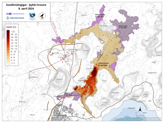
The average lava flow from the craters between April 3 and 8 is estimated at 3.6 ± 0.7 m3/s. Based on data collected by the Efla Engineering Institute on April 3rd during a drone flight, the average lava flow was estimated at 6.6 ± 0.3 m3/s from March 27th to April 3rd. The area of the lava bed is 6.14 km 2 and the volume is 31.3 million m3. Recently, lava has flowed mostly south from the crater, but it temporarily flowed a short distance to the north on Sunday evening (April 7) when the rim of the crater ruptured, as discussed in the last news update. As can be seen on the attached map, the lava has thickened the most near the crater and a little south of them, where there is the most activity in the lava bed. There are no clear signs of lava advance at the dikes north of Grindavík, Suðurstrandarveg or Melhólsnámu.


Grindavik_Svartsengi_lava_thickness_map_8april2024


A map showing the extent and thickness of the lava formed during the current eruption. Purple covers show lava that has flowed in the area since December 2023.


(Click on the map for a larger view)


Landslide speed increased in the past week​


Landris in Svartsengi continues and its speed has increased in the past week at the same time as the power of the eruption has decreased. It indicates that the majority of the magma that flows under Svartsengi gathers there, causing increased pressure and land mass. During the eruption, however, there is still an open connection between the magma collection area in Svartsengi and the Sundhnúks crater series, and part of the magma flows to the surface there.


Seismic activity in the magma tunnel at Grindavík has continued to be very low, and is mainly between Sýlingarfell and Stóra-Scógfell, but also only in the western part of Grindavík. At Fagradalsfjall, the small earthquake activity that has been ongoing for the past few months continues, and they remain very localized at a depth of about 6-7 km.


Gas measurements carried out yesterday, April 8, estimate that 10-18 kg/s of sulfur dioxide (SO 2 ) flow from the craters. Temporarily high levels of SO 2 continue to be measured around the eruption and in settlements on the Reykjanes Peninsula. Gas emissions from the volcanic eruption are likely to cause pollution on the Reykjanes Peninsula, and we advise people in the area to monitor air quality and learn about reactions to air pollution from the volcanic eruption.


According to the weather forecast, there will be a breeze from the north today and the gas pollution will travel to the south. Slow changing direction in the afternoon and then there is a chance of contamination near the eruption centers. East and southeast tomorrow and the gas pollution will then reach the west and northwest. Gas distribution forecast here .


Risk assessment unchanged.​


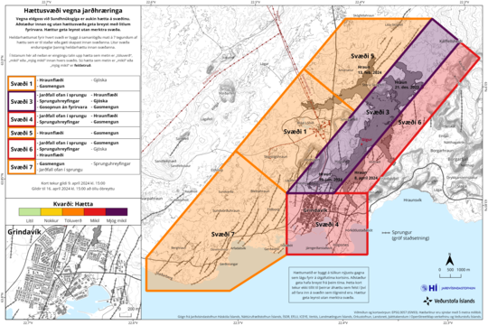
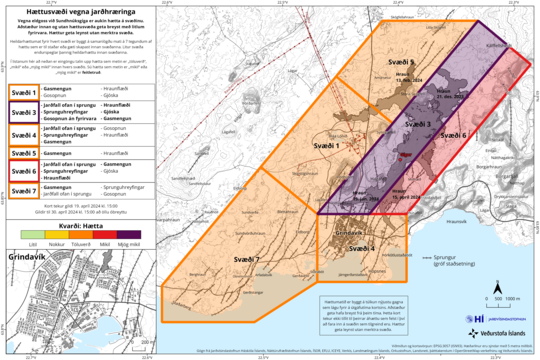
The risk assessment has been updated and is valid from 15:00 today until April 16, all things being equal. There are no changes in the risk assessment and the risk caused by gas pollution is still assessed as high in all areas except for the Sundhnúks crater series (area 3) where it is assessed as very high. The risk in area 4 (Grindavík) and area 6 is still assessed as high due to landfall into the fissure, fissure movements, lava flow and gas contamination.


Haettusvaedi_VI_9april_2024


(Click on the map for a larger view)


Although the power of the eruption has decreased, there are no signs that the overall flow of magma from depth is decreasing. It refers to the total amount of magma that accumulates under Svartsengi, plus the magma that flows to the surface during the eruption of the Sundhnúks crater series. It is difficult to predict when this eruption will end, it could continue for a longer time with constant flow or stop in the near future. As magma continues to accumulate under Svartsengi and the pressure there increases, there is also a possibility that the power of the eruption will increase again, as happened in Fagradalsfjall 2021. If the eruption stops in the near future, it is most likely that magma accumulation will continue under Svartsengi and a similar scenario, as seen in the last months, will repeat itself.


It's not just the currently erupting crater, although that is a real hazard to Grindavik and other settlements down to the sea.

Something as big as the peninsula is doing something down there, and no one (I suspect) knows exactly what's involved -- yet it matters very much because so many people and their property are at risk.

More locally, as long as that inflow continues from below into the Svartsengi sill, there will be quakes and eruptions. Will these stay near the old Sundhnukur craters or, like so many Reykjanes Ridge processes, migrate south?

There's just so much going on here that I haven't seen at other volcanoes.
 

bjdeming

Member
Sustaining Member
Messages
1,602
Reaction score
1,318
Location
Corvallis, Oregon
A 3D model of the eruption site as it was on Monday afternoon. Among other things, it allows experts to get an area measurement, per Morning Paper (autotranslated).
 

bjdeming

Member
Sustaining Member
Messages
1,602
Reaction score
1,318
Location
Corvallis, Oregon
An earthquake swarm has started southwest of Thorbjorn, reportedly (autotranslated).

The interesting thing in that article to this layperson is that the IMO specialist isn't quoted as giving the usual "it's triggered by ongoing stresses" answer (most recently, for example, that was the statement about the swarm at the lake Kleifarvatn this past week).

While she says this swarm near Mount Thorbjorn could be triggering, they're not sure what the cause is and are following it closely.

This is totally layperson speculation, but the uncertainty might be due to the fact that this part of the Reykjanes Peninsula is behaving just as it did in between eruptions from December 18 on -- sill inflation, triggered seismicity -- even though it has been erupting since March 16th; it makes me wonder if the Sunduhknur eruption will suddenly intensify or if a new set of eruptive fissures will open up somewhere along the November 10 dike.

Fagradalsfjall is also an option, but recent IMO reports continue to describe just ongoing low-level seismicity at greater depths (8-10 km) there.

It did try to move south earlier this year, with that one small but destructive fissure eruption behind the barrier. This layperson thinks it may try again somewhere in that area or out to sea -- no repeaters, since these all are monogenetic eruptions in an active volcanic fissure zone (some US examples) -- if whatever blocked off that earlier path to the surface opens up.
 

bjdeming

Member
Sustaining Member
Messages
1,602
Reaction score
1,318
Location
Corvallis, Oregon
IMO posted an in-depth report on the swarm a few hours ago (Google translated):

Quite a few small earthquakes (less than 1 magnitude) have been recorded northwest of Grindavík in the last few hours. (See overview images below.) The activity is mostly located within the trough formed on November 10 and is probably due to the effects of the land giant in Svartsengi, which causes voltage changes in the area.


The seismic activity today is similar to the activity measured in this area in the middle of last March. The seismic activity is therefore not a sign of any changes in the activity of the volcano, which has remained fairly stable over the weekend. The seismic activity northwest of Grindavík is also not a sign that magma is on the move under that area.


At the time of writing, the seismicity has only subsided northwest of Grindavík. It is not considered likely that large earthquakes accompany this activity that is currently being measured.


If magma were to look elsewhere than the way it has crossed the Sundhnúks crater series, for example west towards Eldvörp or south of Þorbirn, the precursor to a possible eruption in that area would be very intense earthquakes and deformation that would be clearly visible on measuring instruments and satellite images. There are no signs of that at this point.


The National Weather Service's 24-hour watch continues to monitor the area and the eruption centers.


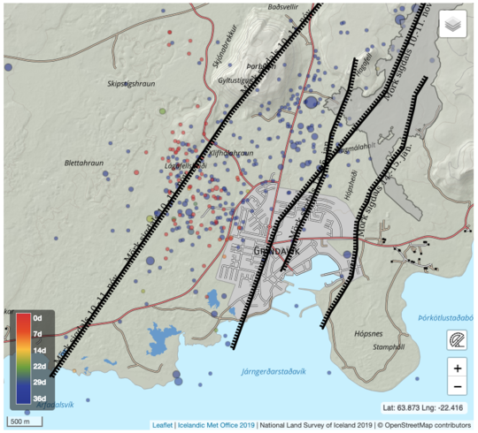
Hrina_14042024_Sigdalur


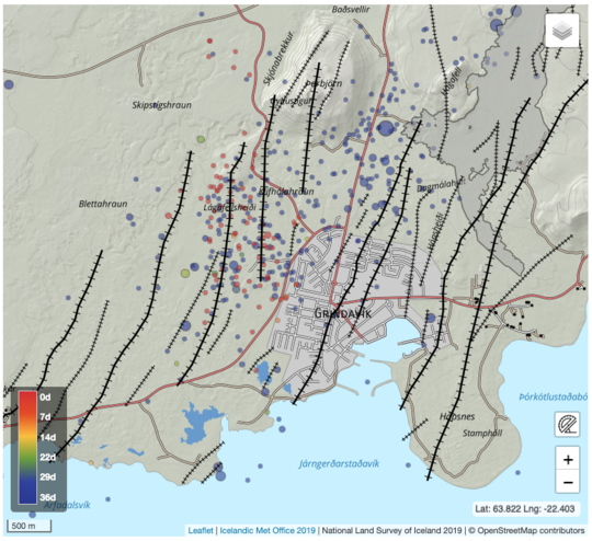
The image shows seismic activity between March 9 and today, April 14. The black lines represent the outer limits of the sickle valleys that formed in connection with the great magma flow on November 10, 2023 and the eruption on January 14 of this year. The vast majority of earthquakes today have been smaller than 1 in magnitude. Blue-colored earthquakes occurred on the 9th-14th. March while red-colored earthquakes occurred today, April 14. The location of the earthquakes is in the western edge of the sigdal that was formed last November 10.


Hrina_14042024_Cracks


In the area northwest of Grindavík there is also an array of well-known cracks with a north-south direction that collapsed when the magma tunnel formed on November 10. Today's earthquakes are therefore also a sign of tension release on these cracks due to the landslide in Svartsengi.
 

bjdeming

Member
Sustaining Member
Messages
1,602
Reaction score
1,318
Location
Corvallis, Oregon
Another update just now from IMO, showing how closely they're following the swarm:

Icelandic Meteorological Office
Menu .

Listen
Gos12042024
A photo taken on Wednesday, April 10, showing the active crater as seen from Sundhnúk. (Photo: Jón Bjarni Friðriksson/Icelands Meteorological Office)

The eruption at Sundhnúka remains constant​

Landris continues at a similar pace since the beginning of April.​

15.4.2024


Updated April 15 at 10:50 a.m

  • The eruption that began on March 16 remains constant
  • Landris continues at a similar pace since the beginning of April.
  • The risk assessment is valid until April 16, all things being equal
  • There is still a risk of gas pollution. We advise people in the area to monitor air quality .
  • Gas distribution forecast can be found here .
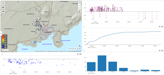
Just after noon yesterday, a series of small earthquakes began at Lágafell, just northwest of Grindavík. It was mostly finished around half past four yesterday. There were about 90 tremors and the activity was greatest between 13 and 14 when 35 earthquakes were measured. All the earthquakes were under magnitude 1 and most of them were about 2-4 km deep. This series of small earthquakes is probably the result of tension changes in the earth's crust due to the ongoing landslide in Svarteng, as discussed in yesterday's news update.
Attached is a composite image showing the location of the earthquakes on a map, and below that is a graph showing their depth. At the top right is shown the magnitude of earthquakes from yesterday afternoon until last night. Below that is the accumulated number of earthquakes and at the bottom the number of earthquakes per hour. As the graves show, several small earthquakes were recorded in the area yesterday afternoon, but after midnight today, no seismic activity has been recorded there.
Trembling14042024

"Probably" to us laypeople is next to "certainly," but its use by scientists has multiple shades of meaning that I'm not qualified to interpret.

<Layperson speculation>
  • It is highly unlikely that another eruption with little to no warning will occur outside the November 10 dike intrusion.
  • If a new eruption from the dike intrusion area occurs, and/or an increase in the current eruption occurs, there might not be much warning (as there wasn't for recent eruptions).
  • Previous eruptions at Sundukhnur and earlier ones at Fagradalsfjall sometimes were preceded by a drop in seismicity while sill inflation continued. If the peculiar (to this layperson) resumption of the old "sill inflation/triggered seismicity" pattern holds, the drop described above might mean that another magna intrusion/lava flow might occur soon.
  • Does Thorbjorn -- AFAIK, a fissure eruption product formed subglacially during the tail end of the Pleistocene, but don't quote me on that -- somehow influence the plumbing/plate boundary movement here (have read that strike of some Reykjanes tectonic features changes in this general area, but will save that for a blog post)?

</Layperson speculation>
 

bjdeming

Member
Sustaining Member
Messages
1,602
Reaction score
1,318
Location
Corvallis, Oregon
Theae details would be arcane, if not for the location. Icelanders have to take such things into account. For instance:

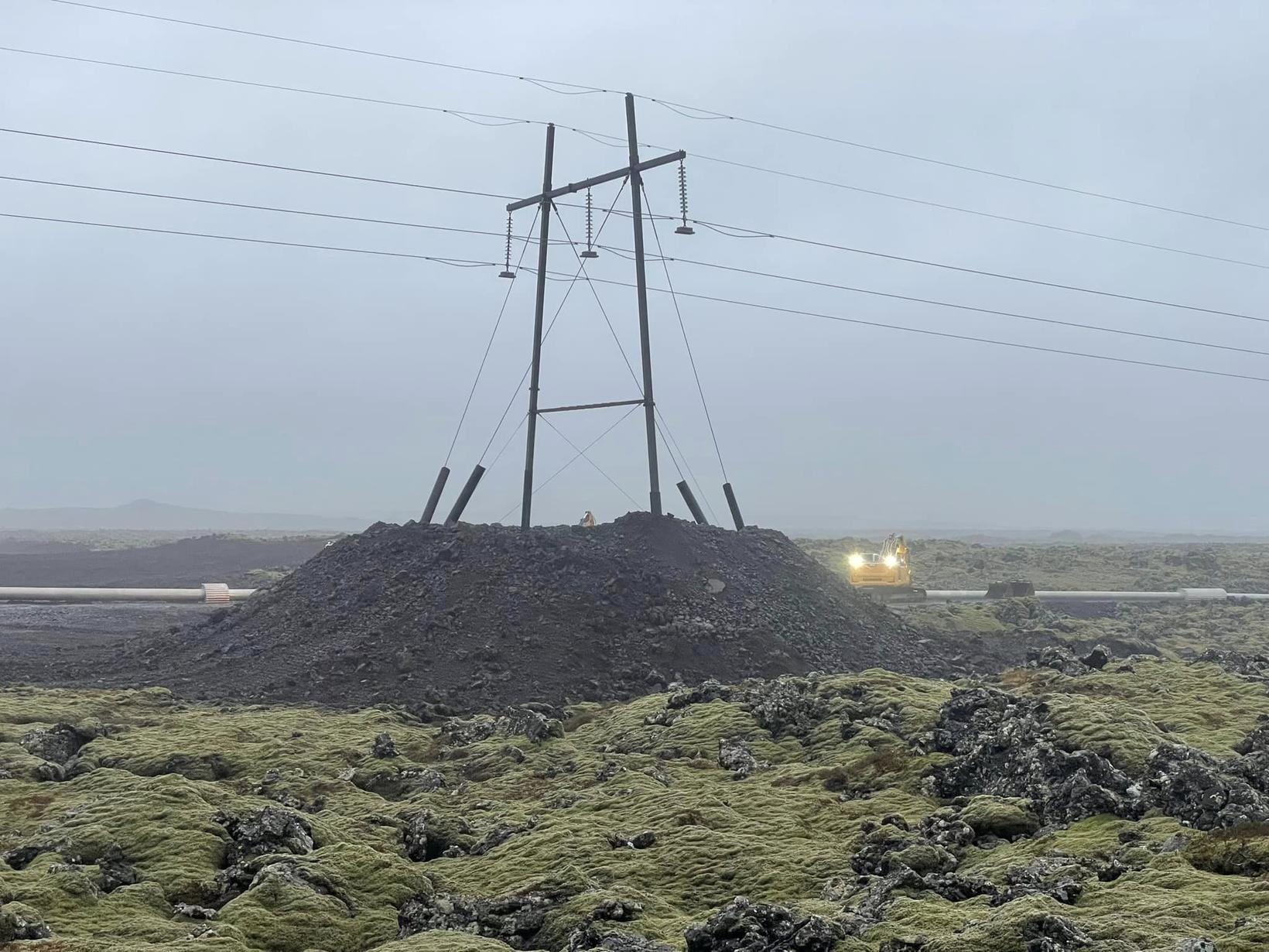
Work to protect the masts in the line started before Christmas. Three new masts have been built and they stand higher in the country than the old ones and one of them is on a raised island...


It is hoped that the increase will prevent…

It is hoped that the elevation will prevent lava from reaching them. Photo/Submitted

Svartsengi connection line will be safer​


The aim of the operation is to protect these masts from lava flows, and the Svartsengis line will therefore be safer.


"These new masts that we have built, they stand outside the lava flow. Hopefully the lava will not flow in this place, but if it does, the masts are higher in the country and therefore possibly withstand the lava flow."

-- Source (autotranslated)

And shielding on the geothermal heat supply pipes hasn't been lava-tested yet, either. At least, they're getting into somewhat warmer conditions now.
 

bjdeming

Member
Sustaining Member
Messages
1,602
Reaction score
1,318
Location
Corvallis, Oregon
This Morning Paper headline (autotranslated) is probably overwrought, since RUV would likely mention it (I didn't see it on their page just now).

Domestic | etc 15.4.2024 | 15:07

Panic around the country​


Kolbein Island. Photo from a collection.

Kolbein Island. Photo from a collection. Photo/Sindre Skrede


Bookmark disabled for non-logged inSet a bookmark

At least three earthquakes have hit Reykjaneshrygg after 14 today, over eighty kilometers southwest of Reykjanes.

The largest earthquake to date measured 3.0 and occurred at 14.08. Two others, smaller, have followed suit.

There was also an earthquake under the ocean floor north of the country yesterday, or almost 200 kilometers north of Kolbeinsey...
 
Last edited:

bjdeming

Member
Sustaining Member
Messages
1,602
Reaction score
1,318
Location
Corvallis, Oregon
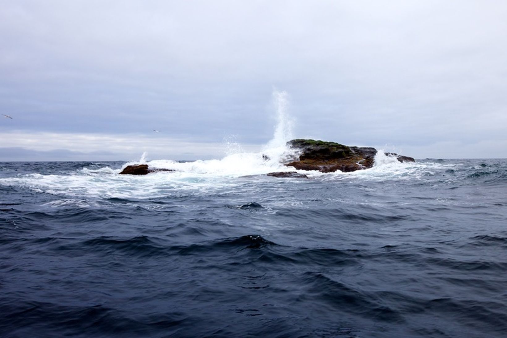
I messed up on the buttons somehow. About that article, the imaged rock and the whole Kolbeinsey area are part of the next segment up on the Mid-Atlantic Ridge.

All of Iceland lies between the Reykjanes and Kolbeinsey ridges, and it is not made of Jello.

Earthquakes in the two areas are unrelated.

The Eldey/Reykjanes peninsula tip area seems to be rocking, though, just as it has before in between eruptions in the Svartsengi area. This February article (autotranslated) goes into that a bit.

Per IMO:

Reykjanes ridge - earthquakes in the last 48 hours.
(Unsurpassed preliminary results)​


The location of the April 15 quake. 19:25​

Map with earthquake locations
quake-legend_is.gif

Timing and magnitude of the April 15 quake. 19:25​

A histogram showing the timing and magnitude of earthquakes


...


Warnings (no warning, normal state)

Updated 10.04
 

bjdeming

Member
Sustaining Member
Messages
1,602
Reaction score
1,318
Location
Corvallis, Oregon
Today IMO posted a detailed one-month assessment (autotranslated) of this ongoing eruption and the current situation.

The whole thing is worth reading -- a few points that struck me include:

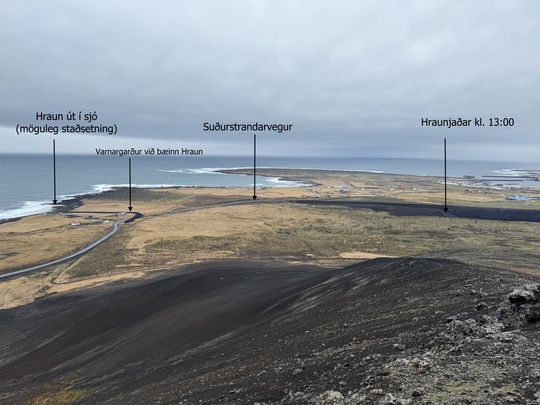
• The barrier they built at Hraun.


Hraunjadar_Sudurstrond_17032023_1300

The progress of the lava towards Suðurstrandarvegur was closely monitored due to the possibility that lava would flow over Suðurstrandarvegur and even to the sea. Photo taken on March 17.
Grindavik: YOU SHALL NOT PASS!

Hraun: Nope.

That image just sums up the Icelandic spirit -- and their earth-moving capabilities. They built that berm overnight!

• The GIF showing extent of each eruption:


lava_time_series.gif


• The closing, which everyone here will certainly appreciate even if it's in a different field of Earth science:

"The current situation is new, as there is an eruption in the Sundhnúksgíga series and land is rising in Svartsengi at the same time. The most important thing in the situation now is the same as before, to patrol the area and respond correctly to the changes that occur in the activity each time to prevent further damage and people being in danger due to the upheaval."
 

bjdeming

Member
Sustaining Member
Messages
1,602
Reaction score
1,318
Location
Corvallis, Oregon
A drive along one of Grindavik's barriers (h/t FragenuberF, Twitter):


They worked their design into the local topography, so it's hard to say where the work of humans leaves off and Nature takes over.
 

bjdeming

Member
Sustaining Member
Messages
1,602
Reaction score
1,318
Location
Corvallis, Oregon
The crater is dark at the moment, but I saw no new updates on IMO's website.

This RUV article (autotranslated) shows how edgy everyone is (except some oblivious Blue Lagoon guests, apparently), waiting for whatever will come next.

This layperson's guess is that the dramatic decrease at the vent is an equivalent of that drop in seismicity that has occurred just before some of the earlier eruptions here and in Fagradalsfjall.

Waiting...
 

bjdeming

Member
Sustaining Member
Messages
1,602
Reaction score
1,318
Location
Corvallis, Oregon
From yesterday (was busy and missed it):

Civil defense increases preparedness​


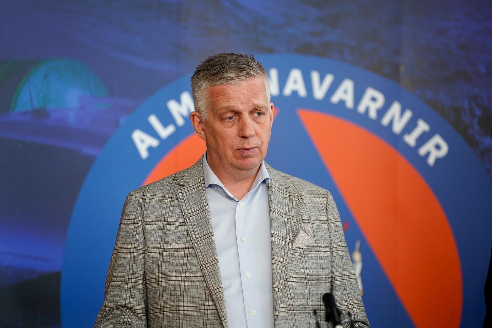
Víðir says preparedness has been increased due to the accumulation of magma under Svartsengi.

Víðir says preparedness has been increased due to the accumulation of magma under Svartsengi. mbl.is/Ottar
...

"We have increased our preparedness and added personnel, as the accumulation of magma under Svartsengi is approaching this lower limit, which is around eight cubic kilometers, so now something could happen next week," says Víðir Reynisson, senior police officer of the Public Safety Department of the National Police, to mbl.is about heightened preparedness due to the risk of eruption on the Reykjanes Peninsula.

-- Source (autotranslated)
 

bjdeming

Member
Sustaining Member
Messages
1,602
Reaction score
1,318
Location
Corvallis, Oregon
Actually, I missed the Friday update and the prediction part -- "likely sequence" -- at the end is important ("magma flow" sometimes means "dike intrusion"):

Gos12042024
Photo taken on Wednesday, April 10, showing the active crater as seen from Sundhnúk. (Photo: Jón Bjarni Friðriksson/Icelands Meteorological Office)


Continued landrising increases the likelihood of another magma flow even though an eruption is ongoing​


More uncertainty about the development of the earthquakes in the coming days or weeks​


19.4.2024

Updated April 19 at 14:55

  • Landris in Svartsengi continues at a steady pace
  • Since April 5, only one crater has erupted and the lava flow from it has remained fairly constant since then, just over 3m 3 /s
  • There is still a risk of gas pollution. We advise people in the area to monitor air quality .
  • The weather watch's forecast for gas distribution can be found here
  • If the accumulation of magma under Svartsengi continues at a similar rate, the probability of another magma flow increases in the coming days or weeks, even though the eruption is still ongoing.


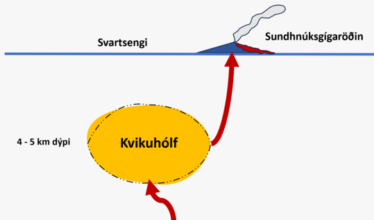
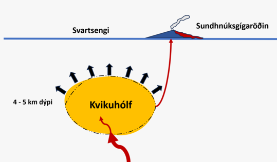
After the fourth eruption began on March 16, landrising slowed down significantly for a while and almost stopped. It indicated that there was a balance between the inflow of magma into the magma chamber under Svartsengi and to the surface in the Sundhnúks crater series (Fig. 1).

At the beginning of April, land pressure began to increase again, and now approximately as much of the magma is flowing to the surface as is accumulating in the magma chamber under Svartsengi with the associated increased magma pressure (Figure 2).

The current situation is new, as a volcanic eruption with fairly constant lava flow is going on in the Sundhnúks crater series at the same time as land is rising in Svartsengi. Therefore, there is more uncertainty now than before about the possible development of the event.

Magma flow_1

(Figure 1)

Magma flow_2

(Figure 2)

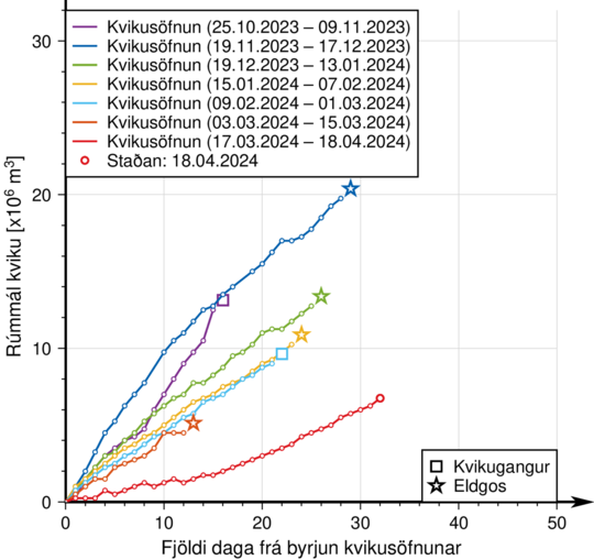
Model calculations assume that more than 6 million m 3 of magma has now been added to the magma chamber under Svartsengi since March 16. In previous events, magma has flowed from Svartsengi when between 8 and 13 million m 3 have been added to the magma chamber since the last event.


Graf19042024

The graph shows the estimated amount of magma that has been added under Svartsengi between the eruptions or magma flows that have occurred since November 2023.

More uncertainty about the development of the earthquakes in the coming days or weeks​


So far, there has been talk of an increased probability of a magma flow and even a subsequent eruption in connection with the sequence of events in the Sundhnúks crater series. It's good to remember that a magma flow is a sudden and large flow of magma that flows out of a magma chamber and can end up with magma breaking up to the surface. After the magma run on March 2, which did not end in an eruption, there was a change in the activity that had been fairly stable since December.

If magma accumulation continues at a similar rate, the probability of another magma flow increases in the coming days or weeks, even though the eruption is still ongoing. Getting magma flow out of the magma chamber in Svartsengi together with the current eruption is a scenario that has not been seen before. There is therefore more uncertainty about the development of the earthquakes in the coming days or weeks.

A likely sequence of events if a magma flow occurs at the same time as a current eruption:

  • Magma flows from the magma chamber under Svartsengi into the Sundhnúks crater sequence, just like the last six times.
  • As a result of the magma flow, new fissures may open in the area between Stóra-Scógfell and Hagafell or/and existing vents may expand with a sudden increase in lava flow. It could happen with very little or no notice.
  • If a magma flow ends with new fissures opening up elsewhere in the magma tunnel that formed on November 10, a much longer notice can be expected, most likely intense micro-seismic activity, deformation and pressure changes in boreholes.
  • It is also possible that there will not be a magma flow, but that the flow in the current eruption stops decreasing and begins to increase steadily until a new balance between the inflow of magma from below and the flow to the surface from the crater is reached.
  • If a magma flow ends with new fissures opening somewhere other than in the area between Stóra-Scógfell and Hagafell, such a scenario would very likely be accompanied by high seismic activity and deformation with considerably more advance notice than previous volcanic eruptions.

Updated hazard assessment​


In light of the uncertainty caused by the increasing pressure in the magma chamber under Svartsengi, the Norwegian Meteorological Agency has raised the risk due to the eruption in areas 1, 4 and 7 from"small"in"considerable". However, the total risk (color) in the affected areas does not change because of this.
Haettusvaedi_VI_19april_2024
 

bjdeming

Member
Sustaining Member
Messages
1,602
Reaction score
1,318
Location
Corvallis, Oregon
The crater never went out completely and tonight it's open for business -- ?? normal variation or a sign of coming increase. (I never understood why it overflowed briefly, either.)

There's no news.

Right now on the cams the level of lava in the crater is high but not unusually so.
 

bjdeming

Member
Sustaining Member
Messages
1,602
Reaction score
1,318
Location
Corvallis, Oregon
From IMO's latest update (about half an hour ago), emphasis added:

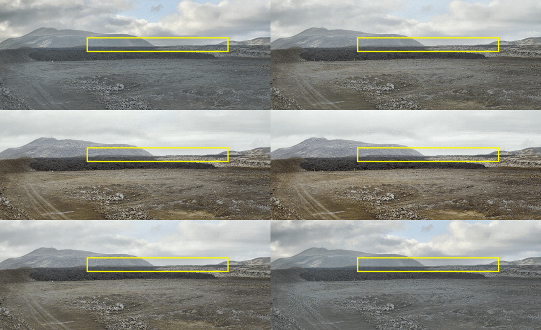
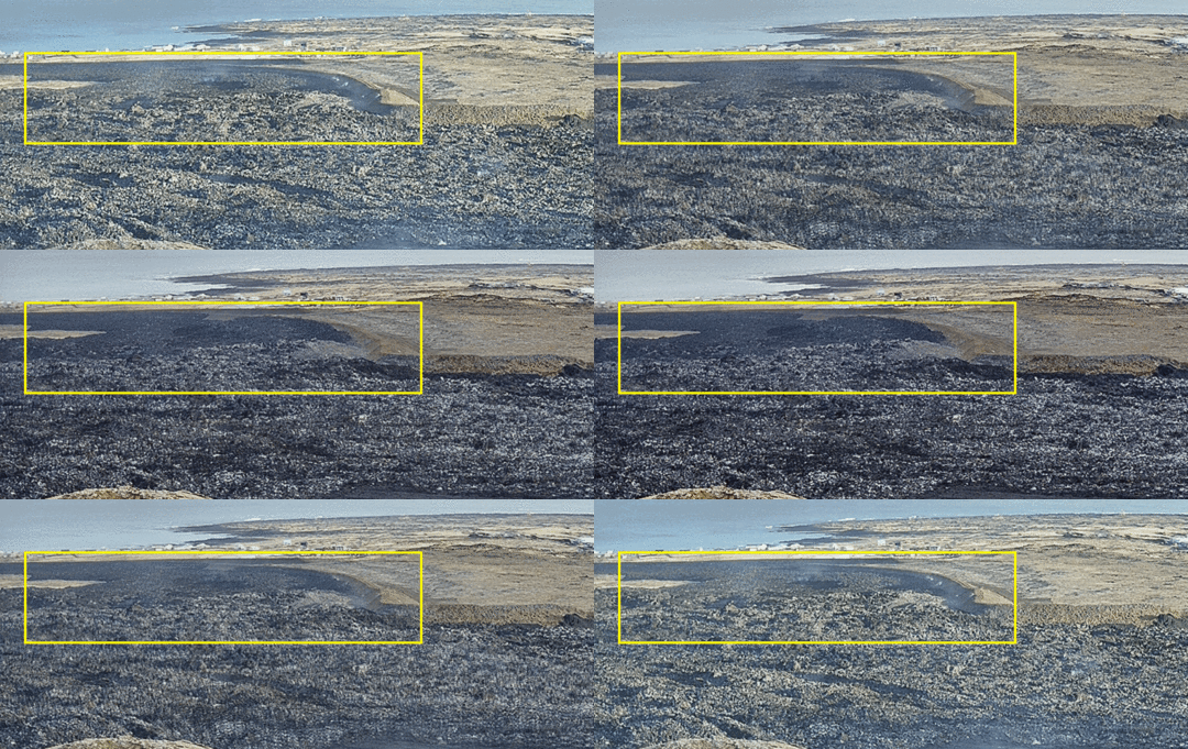
...As before, lava flows a short distance in an open lava river to the south from the crater, but further in closed channels. The part of the lava bed that runs along the defenses to the east of Grindavík has thickened in recent days, as the accompanying animations show. The pictures show the difference in lava width between 18 and 23 April. The upper images are from the National Defense's web camera, which is located on a dike east of Grindavík and looks at the lava flow that flowed towards Suðurstrandarvégur at the beginning of the eruption. The lower pictures are also from Alm's webcamannavarna located on top of Hagafell and looking south.


8c6cfe1b-c87b-4501-bd10-41e7c2079707


Images from the National Defense web camera located on a defense wall east of Grindavík and looking at the lava flow that flowed towards Suðurstrandarvégur at the beginning of the eruption. A yellow box is around the area of the lava bed that thickens the most during the season.


57f4a945-2487-4adc-af84-b11fcc474350


Pictures from the web camera of the National Defense which is located at the top of Hagafell and looks south. A yellow box marks an area where the lava near the dikes has thickened the most.


Measurements of the lava flow in the eruption show that since the beginning of April it has been between 3 and 4 m 3 /s. The last measurements are since April 15th, and it is expected that new results will be available next week, which will shed light on whether there have been measurable changes in the lava flow since April 15th.


Landris in Svartsengi is measured at a similar rate, which indicates that magma accumulation continues. Model calculations based on GPS and satellite data estimate that around 7 to 8 million m 3 have been added to the magma chamber under Svartsengi since the eruption began on March 16. In previous magma flows, magma has flowed from Svartsengi when between 8 and 13 million m 3 have been added to the magma chamber since the last magma flow.


If magma accumulation continues at a similar rate, the probability that the power of the eruption on the Sundhnúks crater series will increase significantly increases.


  • New fissures open in the area between Stóra-Skógfell and Hagafell or/and an existing fissure expands due to a sudden increase in lava flow that could be comparable to the initial phase of the last eruptions in the area. It could happen with very little or no notice.
  • It is also possible that magma flow from the magma chamber under Svartsengi to the Sundhnúks crater series will gradually increase until there is a balance between the inflow of magma into the magma chamber and the outflow from there to the surface.


It is also possible that there will be a magma run that ends with new fissures opening elsewhere than in the area between Stóra-Skógfell and Hagafell. This scenario is considered less likely than the others and would be accompanied by considerable seismic activity and deformation with greater advance notice than past eruptions.

Perhaps that one overflow was the sill's attempt to empty out a bit and it just lacked oomph for some reason at that point

Of note, some organizations are pushing to get the crater area turned into a tourist attraction. It would bring in money -- already people are trying to get in and recently someone got their car stranded out there!

But imagine being out there and all of a sudden this single crater transforms into an opening fountain sequence again...

Brrr.

In other news, businesses that are trying to stay alive in Grindavik are asking for more government assistance.

The whole private property situation is quite confusing to this outsider, with various institutions involved and so forth. My general impression, whether correct or not, is that many people are trying to close down their connections there while salvaging as much as they can, in material and financial terms. The human cost, of course, is beyond words.
 
Logo 468x120
Back
Top