• Welcome to TalkWeather!
    We see you lurking around TalkWeather! Take the extra step and join us today to view attachments, see less ads and maybe even join the discussion.
    CLICK TO JOIN TALKWEATHER

50th Anniversary of the April 3-4, 1974 Super Outbreak

Messages
2,233
Reaction score
2,823
Location
Missouri
Fun Facts: The Guin, AL F5 started in Monroe County, MS and Monroe County MS is the ONLY county in North MS that has had 2 F/EF5 tornadoes. First one was the Guin, AL F5 and then the Smithville, MS EF5 in 2011.

What makes it even more ironic is that each one occurred during both Super Outbreaks.
That whole area stretching from central MS to northern AL is a magnet for violent tornadoes. In particular, the section of northwestern Alabama from Marion and Lamar Counties to Limestone and Madison Counties, four F5s hit that area during the 20th century, three of them occurring during the Super Outbreak of 1974. And of course that area was struck again on 4/27/11.
 

Mike S

Administrator
Staff member
Administrator
Moderator
PerryW Project Supporter
Messages
2,011
Reaction score
1,173
Location
Meridianville, Al
Special Affiliations
  1. SKYWARN® Volunteer
None of the 4 Huntsville stations have even a mention on their websites, which means they have not done anything on their newscasts as well.

That is especially egregious for WHNT considering HD Bagley is a Huntsville legend in large part because of that night.
All the locals except WZDX finally put something up on their websites.
 

A Guy

Member
Messages
171
Reaction score
344
Location
Australia
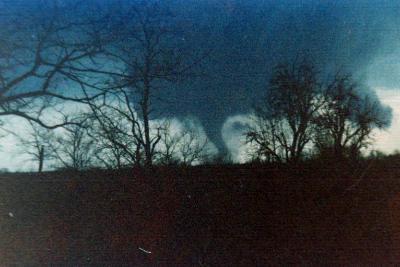
My guess is the photo is either of Tanner or Guin. The poor quality makes me wonder if it's a doctored or bootlegged photo of something else.
That picture quality isn't out of the question for cheaply reproduced low quality media - not sure of the whats of the printing process, but if you read old reports on weather events or other scientific topics you'll get photos of that quality often enough.

It could potentially be a photo of a completely different tornado, but if it is genuine then Tanner I is the safest bet, firstly it's implied by the caption and the known tracks, and secondly it would have been completely dark by the time the Guin tornado reached that area.

Order of magnitude is a gross understatement regarding pressure gradient.
In tornadoes the pressure can get so slow it becomes close to a legitimate vacuum while a couple dozen meters away the pressure is above a 1000mb. Which explains how tornadoes are able to crack and pull concrete slabs due to the mind numbing rapid changes in air pressure.
Tropical cyclones like the most intense on record, typhoon Tip can only get down to 870mb.

Tornadic wind speeds are definitely vastly underestimated. Even the weakest of tornados likely have instantaneous winds over 200mph minimum that simply can’t be detected by radar.
Wind dynamics can only do so much to explain the vast differences in degree of damage despite having “the same wind speeds” between the two.

Edit: None of these words are directed at you by the way. I’m simply talking about the rating process as a whole.
Bit of an exaggeration. Karstens et al. reviewed pressure drops. The largest is 194 mbar, but it's (IMO) one of the more suspect ones, most are much less. Manchester SD's (reliable) drop of 100 mbar is in the range of strong tropical cyclones. Obviously the steep pressure gradient is very important for the powerful windfield, but I'm not sure the "200 mph" statement is that helpful or true - after all many tornadoes cause no damage. I think it's increasingly clear the EF scale underestimates windspeed (even when not applied in the current, often pig-headed manner) but the unusual windfield dynamics are, from what I've gathered, likely an important factor in why tornadoes can be so destructive.
 
Last edited:
Messages
2,855
Reaction score
4,645
Location
Madison, WI
One needs only go to the top of the tornado list to clearly see one of the inconsistencies that makes comparisons between outbreaks from different eras so difficult. The very first tornado of the afternoon of April 3 is described as a "brief touchdown in an open field" with a 0.12 mile, 50-yard wide path, yet somehow has an F2 rating? Possibly applied by Fujita himself due to cycloidal marks in the field seen on his aerial survey or something? The same type of thing that would surely be rated EF0 or EFU today.


jbn60

Member
Messages
8
Reaction score
16
Location
Madison, AL
WAAY 31 had installed their own crude radar a week before April 3 and thus were the only station that could show the radar live. The WAAY weatherman at the time the Guin storm was approaching Huntsville became so excited that he began to hyperventilate and they had to cut to a commercial in order for him to regain his composure. There actually were 2 funnels in the storm with the southern funnel going through south Huntsville and the original funnel mostly aloft over north Huntsville. The lightening was incredible to see.
 

mdennis

Member
Messages
3
Reaction score
25
Location
Trussville, AL
My g

My guess is the photo is either of Tanner or Guin. The poor quality makes me wonder if it's a doctored or bootlegged photo of something else
I’m from Tanner originally, and I think those photos may be from around the Hazel Green area. The caption mentions Greenville Pike and that’s in Madison county I could be totally wrong, though.
 
Messages
272
Reaction score
239
Location
Smoke Rise, AL (25 mi. N of downtown Birmingham)
I was 7 y/o when this outbreak happened and lived in Memphis. I don't have any recollection of it, most likely because our area wasn't affected. I was already weather aware by that age and checked out books from the library about tornadoes and other weather phenomena. I do remember reading a book about the Xenia tornado later during the 1970's. I recall a tornado day during 2nd or 3rd Grade when we all had to pile into a first level section of a building attached to our school (affiliated with a Methodist church), but that could have been any random event during that period. I distinctly remember Dave Brown from WMC TV (or maybe WHBQ at that time) mentioning the April 1977 tornado in Birmingham.
 
Messages
2,233
Reaction score
2,823
Location
Missouri
A couple of days late to the party but this is apparently a book of Guin that was scanned in for the 50th anniversary. A ton of damage pics I haven't seen anywhere else:

 
Messages
2,233
Reaction score
2,823
Location
Missouri
That picture quality isn't out of the question for cheaply reproduced low quality media - not sure of the whats of the printing process, but if you read old reports on weather events or other scientific topics you'll get photos of that quality often enough.

It could potentially be a photo of a completely different tornado, but if it is genuine then Tanner I is the safest bet, firstly it's implied by the caption and the known tracks, and secondly it would have been completely dark by the time the Guin tornado reached that area.


Bit of an exaggeration. Karstens et al. reviewed pressure drops. The largest is 194 mbar, but it's (IMO) one of the more suspect ones, most are much less. Manchester SD's (reliable) drop of 100 mbar is in the range of strong tropical cyclones. Obviously the steep pressure gradient is very important for the powerful windfield, but I'm not sure the "200 mph" statement is that helpful or true - after all many tornadoes cause no damage. I think it's increasingly clear the EF scale underestimates windspeed (even when not applied in the current, often pig-headed manner) but the unusual windfield dynamics are, from what I've gathered, likely an important factor in why tornadoes can be so destructive.

What do you make of this? This is supposedly of the Guin tornado, according to this FB post:


18033795_1416803931711456_1623153173954805551_n.jpg
 

A Guy

Member
Messages
171
Reaction score
344
Location
Australia
What do you make of this? This is supposedly of the Guin tornado, according to this FB post:


View attachment 25022

Looks like a poor photo of a dark cloud with a tree on the right that could have been taken any time over a fifty plus year timespan. The tornado struck the town at 9:02 pm when it would have been completely dark, that photo, to the extent is shows anything at all, looks like it was taken in daylight.
 
Last edited:
Messages
2,233
Reaction score
2,823
Location
Missouri

warneagle

Member
Messages
3,858
Reaction score
3,498
Location
Arlington, VA
Special Affiliations
  1. SKYWARN® Volunteer
Looks like a poor photo of a dark cloud with a tree on the right that could have been taken any time over a fifty plus year timespan. The tornado struck the town at 9:02 pm when it would have been completely dark, that photo, to the extent is shows anything at all, looks like it was taken in daylight.
And whatever it is was photographed with a potato
 
Back
Top