
-
Welcome to TalkWeather! We see you lurking around TalkWeather! Take the extra step and join us today to view attachments, see less ads and maybe even join the discussion. CLICK TO JOIN TALKWEATHER -
 April 2024 Weather Video of the Month Post your nominations now!

You are using an out of date browser. It may not display this or other websites correctly.
You should upgrade or use an alternative browser.
You should upgrade or use an alternative browser.
Severe WX Historic April 27-May 1 2024 Midwest Storms
- Thread starter CheeselandSkies
- Start date

lake.effect
Member
The Globals are already popping off PDS TOR soundings in the 180-210 hour range. Pretty rare to see that.Casual Super Outbreak analog popping up practically right over my head. Good thing it's 204 hours out.
NorthGaWeather
Member
Definitely something to watch as 00z GEFS/EPS are developing lower heights in the west with a series of shortwaves ejecting. Clearly some timing and amplification spread.
jiharris0220
Member
If the models stay consistent through 120-80hr range, which so far has just not happened this year, then we can expect a higher confidence forecast.
The borderline march 31st super outbreak had basically every single model both global and mesoscale consistently show volatile kinematics and robust UH streaks over the risk area right up until it happened.
Obviously that was an appropriate high risk, but these are the indicators that we should definitely look out for regarding on uncertainty.
JPWX
Member
O yeah I forgot about that LOL!I know one thing for sure - I will NOT be making a thread for this!
Judging by the fact that we finally have days of deep return flow for moisture juxtaposed with the upcoming western troughing regime, I’d imagine the period towards next weekend is going to get quite interesting. Anybody’s guess at this point what the bigger potential days are, but I’m thinking 4/26 (Friday) will be the first as a lead shortwave trough ejects northeastward through the Central Plains. The GFS/GEFS are likely too fast.
JPWX
Member
12z GEFS 500mb, 500+ CAPE probabilities, SCP Greater than 1 Probabilities, and SCP Greater than 5 Probabilities (06z April 25th thru 00z May 1st)
Attachments


Shakespeare 2016
Member
Not quite as crazy as the woman who wants an EF5 tornado in her backyard.Well if we were to have one it would be on my 30th Birthday weekend. My birthday is April 28th. To be honest, that's the most aggressive I've seen in a good while over MS. O boy. (And no I did not send out a birthday invitation to damaging winds, tornadoes, and hail)
JPWX
Member
O lordNot quite as crazy as the woman who wants an EF5 tornado in her backyard.
Shakespeare 2016
Member
It was a meme posted by member TH2002 I believe in Significant Tornado Events. Some of the people in the meme also said something like defund the NWS/SPC.O lord
JPWX
Member
Ah okay. That makes better senseIt was a meme posted by member TH2002 I believe in Significant Tornado Events. Some of the people in the meme also said something like defund the NWS/SPC.
JPWX
Member
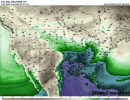
18z GEFS 500mb, Dewpoint Mean, etc.
Attachments


tennessee storm chaser
Member
Any shear at all with those numbers spell big time trouble potential for sure18z GEFS 500mb, Dewpoint Mean, etc.
JPWX
Member
I answered my own question. The GFS is the most aggressive with high dewpoints than the Euro and Canadian.
Attachments


NorthGaWeather
Member
The trough would induce a strong low level response and sufficient deep layer shear. While a lot will change, focus on the synoptics. As Andy mentioned, a shortwave ejecting atop a moist boundary layer as shown by ensemble runs is trouble.Any shear at all with those numbers spell big time trouble potential for sure
Timhsv
Member
OHX already hinting a little:
XUS64 KOHX 201718
AFDOHX
Area Forecast Discussion
National Weather Service Nashville TN
1218 PM CDT Sat Apr 20 2024
Edited for emphasis:
For the next significant chance of rain and thunderstorms, we
have to look ahead to next weekend as a large upper-level low digs
into the southwestern US, resulting in southwesterly flow aloft
and moisture advection across Middle TN. This will set the stage
for a more active and potentially stormy pattern for next weekend.
jiharris0220
Member
GEFS is consistently showing height falls in the west coast U.S /-PNA. These height falls begin on April 25, Thursday and last until at least April 30th, Tuesday. This indicates slow atmospheric angular momentum, which means the troughs that form from these height falls will be large and slow.
Which will give the atmosphere out ahead plenty of time to moisten plus destabilize, and lots of lead way to recharge. This won’t be a situation where the storms, if any should initiate, will have to catch up to the kinematics, as they will already be in place well before them.


Both the GEFS and EPS show a stout trough with a potent jet streak running through the central U.S. We all have seen this tune be played before to know this kind of look leads to significant outcomes.


Obviously however, the specifics are way too far out to be determined, and this could easily backtrack with the way this year has gone, but so far, by all means this smells like a classic multi day central plains severe weather outbreak.
Which will give the atmosphere out ahead plenty of time to moisten plus destabilize, and lots of lead way to recharge. This won’t be a situation where the storms, if any should initiate, will have to catch up to the kinematics, as they will already be in place well before them.
Both the GEFS and EPS show a stout trough with a potent jet streak running through the central U.S. We all have seen this tune be played before to know this kind of look leads to significant outcomes.
Obviously however, the specifics are way too far out to be determined, and this could easily backtrack with the way this year has gone, but so far, by all means this smells like a classic multi day central plains severe weather outbreak.