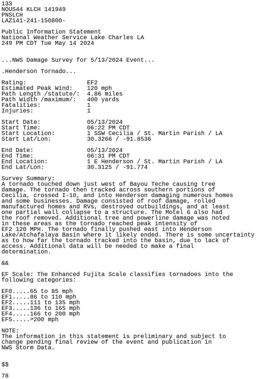
• Welcome to TalkWeather!
    We see you lurking around TalkWeather! Take the extra step and join us today to view attachments, see less ads and maybe even join the discussion.
    CLICK TO JOIN TALKWEATHER
  • April 2024 Weather Video of the Month
    Post your nominations now!
Logo 468x120

Severe Thread: 5/13-17

Clancy

Member
Messages
3,441
Reaction score
6,510
Location
Macland, Georgia
Slight Risk introduced across parts of far southern KY, TN, AL and GA for winds and hail.
1715691995326.png
Valid 141300Z - 151200Z

...THERE IS A SLIGHT RISK OF SEVERE THUNDERSTORMS ACROSS THE
SOUTHEAST STATES...

...SUMMARY...
Severe thunderstorms are possible today over parts of central and
northern Florida and southeast Georgia, with damaging gusts and a
tornado or two possible. Severe storms may also occur across
portions of the Ohio and Tennessee Valleys into the Carolina
Piedmont, as well as the central Rockies/High Plains and parts of
west Texas.

...Northern/central Florida and southern Georgia...
A well-organized quasi-linear MCS will continue across far southeast
Georgia toward southern South Carolina this morning, with at least a
localized severe risk possible. Additional development may occur
along the southwestward-trailing outflow that should modify during
the day, while other storms ongoing over the Gulf of Mexico may also
reach the central Florida Peninsula. With moderate destabilization
(2000-3000 J/kg MLCAPE) and steep lapse rates (reference 12z
observed soundings) along/south of the effective boundary, modest
low-level hodograph curvature and some elongation suggests that
embedded bowing structures and mesovortices could develop,
accompanied by a damaging gust and tornado risk. For additional
short-term details, see Mesoscale Discussion 780.

...Ohio/Tennessee Valleys to the Carolinas...
Deep-layer moisture will advect northward ahead of a meandering
surface low, beneath a nearly uncapped troposphere. As such, diurnal
heating needs only to boost surface temperatures into the lower 70s
F to initiate convection. These temperatures, along with low to mid
60s F dewpoints, will support around 1000 J/kg SBCAPE by afternoon.
Flow aloft is generally not expected to be overly strong, with
slightly curved and short hodographs likely resulting in mainly
pulse multicellular storms, although some supercells are possible
across the Tennessee Valley toward southern Appalachians. Damaging
gusts and hail will be the main threats, though a brief tornado or
two could occur.
 

jaymackd3

Member
Messages
8
Reaction score
18
Location
Huntsville, AL
1715710268303.png

Mesoscale Discussion 0782
NWS Storm Prediction Center Norman OK
1244 PM CDT Tue May 14 2024

Areas affected...Portions of Middle Tennessee...far northern
Mississippi...and northern Alabama

Concerning...Severe potential...Watch possible

Valid 141744Z - 141845Z

Probability of Watch Issuance...40 percent

SUMMARY...Scattered thunderstorms will continue to develop over the
next 1-3 hours across portions of Middle Tennessee and northern
Alabama. A few severe thunderstorms are expected with a localized
threat of damaging winds near 60 mph and occasional large hail 1 to
1.5 inches in diameter.

DISCUSSION...A broken line of scattered thunderstorms has developed
along a surface trough/weak cold front this afternoon from far
northwest MS through portions of western TN. Recent visible
satellite imagery indicates stratus is beginning to mix out
downstream of an approaching mid to upper level vorticity maximum,
currently located over northwest MS. As this feature continues to
progress eastward, additional thunderstorms are expected to develop.
Dewpoints in the mid 60s and temperatures in the low to mid 70s
under marginal mid level lapse rates are currently yielding around
1000 J/kg of MLCAPE under effective deep layer shear near 30 kt. A
slight improvement to the thermodynamic environment is expected
through this afternoon as destabilization continues, steeper lapse
rates slowly advect northeastward, and cooler temperatures aloft
move overhead. This may be especially true within pockets of
clearing. Multicells with clusters, and perhaps some bowing
segments, will be possible in addition to a few supercells more
likely later in the afternoon. Localized damaging wind gusts near 60
mph and large hail up to 1.5 inches in diameter may accompany the
more robust updrafts. Conditions will be monitored for a possible
severe thunderstorm watch.
 

Maxis_s

Member
Messages
1,004
Reaction score
1,739
Location
Canada
Low level lapse rates don't seem the most ideal, but if that changes then Friday could be a very interesting day to be honest.
 

gangstonc

Member
Messages
2,814
Reaction score
310
Location
Meridianville
HUN for Friday:

Of interest is a strong return of lower level moisture
to the region. The 00Z NAM in particular brings higher levels of
moisture and instability in a rather highly sheared environment.
Forecast soundings from this model look somewhat ominous far as
strong convection is concerned. The other models had decent winds
but lesser lower moisture return, with the ECMWF and Canadian
suggesting this moisture could be intercepted by convection to our
south (like with the system that just departed). This said, some
storms in this sheared environment could become strong to severe,
with damaging wind gusts the main threat. Storm relative helicity
values on Fri time range in the 200-300 m/sec, while CAPE values
were from the single digits to around 300 J/kg from the ECMWF and
Canadian. The NAM was showing CAPES over 2000 in comparison.
 
Top