• Welcome to TalkWeather!
    We see you lurking around TalkWeather! Take the extra step and join us today to view attachments, see less ads and maybe even join the discussion.
    CLICK TO JOIN TALKWEATHER
  • April 2024 Weather Video of the Month
    Post your nominations now!
Logo 468x120

Winter WX January 29-30 Southeast Event

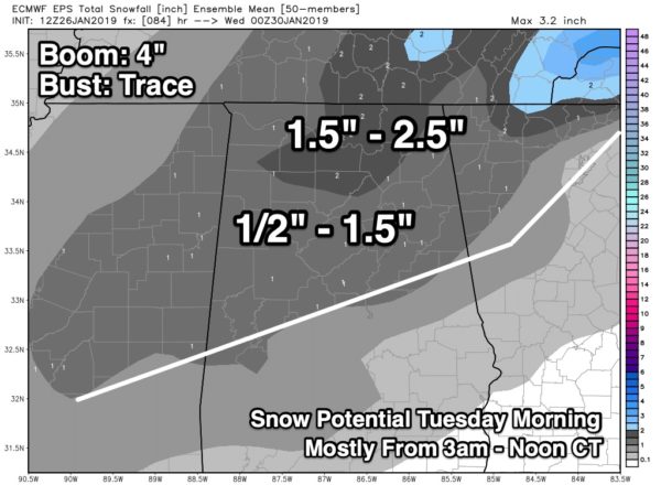
Cool first thread ever and I don't even remember starting it:D Lets hope its good for someone LOL. I seriously doubt this happens this far south in Alabama but at least it looks good in the forecast.

VQP7pzt.jpg


Compared to NWS forecast for Dale Co (More Likely IMO)

Tuesday Night
Colder. Partly cloudy. Rain likely in the evening, then slight chance of rain after midnight. Lows in the mid 20s. Chance of rain 60 percent.
Wednesday
Cooler. Mostly sunny. A 20 percent chance of rain in the morning. Highs in the upper 40s.
 
Latest (?) GFS for Tuesday - per WSFA.

The farther South the snow/ice occurs to less prepared those locations are to deal with it.

1548441757647.png
 
FV3 GFS has 1 inch for as far south as Montgomery and Jackson, Ms getting 2. Canadian coming in more generous with the snow in Huntsville dropping 3 inches. The FV3 GFS is the only model I’ve seen going south of the Tennessee Valley. I don’t have access to the Euro but I think it’s on the higher snow end as well for North Alabama.
 
12z GFS gives us about 2” on Tuesday, which is survivable. All of the snow had just finally melted from last week too.

The GFS-FV3 meanwhile drops 5-6” on us on Tuesday.
 
I could see the snow amounts increasing over time, it looks like the trough wants to dig a bit more with each run giving us a SW flow aloft a bit longer and slowing the front down.
 
NAM too far out to be very useful but it seems to be in pretty good agreement with globals. I like what I'm seeing so far.
 
SREF mean for TCL is abou .6.. not expecting much but this may be the only shot we get this winter. Will be interesting to see how the mean trends. Also saw a good tweet reminding people that the precip being depicted on model data is an average over six hours not real time. This can be confusing for some when looking at output.
 
Look at what the NAM lays down! Impressive snow amounts from middle TN to Birmingham
 

Attachments

  • 1AB67C83-1A24-453B-A579-00E18C735B5F.png
    1AB67C83-1A24-453B-A579-00E18C735B5F.png
    550.4 KB · Views: 0
Spann showing half an inch to 1.5" for Central Alabama. Meh, I mean I'm glad we have a chance for snow but I was hoping it would be more impressive than this. Guess I hung my hat on those early models too soon then.


eps_tsnow_m_birmingham_15-600x450.jpg
 
So far the models are mostly showing at least 1 inch accumulation for Atlanta from roughly noon through 6pm. It looks like the temperature drops to freezing by around noon, then doesn't go back to freezing until around 11am Wednesday. I'm used to borderline temperatures, but once the snow starts, it should get cold and stay there, not hover around 32 so that should boost the ratio a bit.
 

Spann showing half an inch to 1.5" for Central Alabama. Meh, I mean I'm glad we have a chance for snow but I was hoping it would be more impressive than this. Guess I hung my hat on those early models too soon then.


eps_tsnow_m_birmingham_15-600x450.jpg

Spann always conservative on snow amounts especially thus far out and probably for good reason. So if he’s confident calling for an inch this far out tells me something. Now I see he just tweeted about up to 2”...
 
Back
Top