• Welcome to TalkWeather!
    We see you lurking around TalkWeather! Take the extra step and join us today to view attachments, see less ads and maybe even join the discussion.
    CLICK TO JOIN TALKWEATHER

Severe WX April 14-16th, 2023 (Midwest, South)

KevinH

Member
Messages
1,818
Reaction score
2,890
Location
West Central GA
5pm EDT Sunday. Sounding is 6miles SE of Auburn, AL.

CWASPnam212F081.png

nam_2023041312_081_32.55--85.41.png
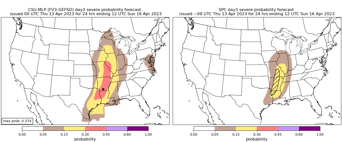
With this kind of data, I expected different wording from the SPC for D4 (4/16/2023) to include Dixie:

“Medium-range guidance is in good agreement that a shortwave trough
will progress from the Mid MS Valley to the Upper Great Lakes on
D4/Sunday, maturing as it does. Thunderstorms are possible over the
Upper OH Valley as the cold front associated with this shortwave
pushes eastward. A few stronger storms are possible along this
front, particularly across OH where the best combination of buoyancy
and shear is anticipated. Thunderstorms will remain possible as the
front continues eastward into the Mid-Atlantic, but limited buoyancy
should keep storm intensity low.”
 

warneagle

Member
Messages
3,855
Reaction score
3,487
Location
Arlington, VA
Special Affiliations
  1. SKYWARN® Volunteer
Impressive hodograph in Southeast Arkansas from 12z NAM for Saturday night......but from what I'm seeing so far....... it appears to be in a very short time window. The favorable kinematics arrive after the best instability starts tapering away.
I think you're getting some convective feedback there.
 

JBishopwx

Member
Sustaining Member
Messages
913
Reaction score
2,041
Location
Ackerman, MS
Special Affiliations
  1. SKYWARN® Volunteer
Today:
SPC.jpg

THERE IS A SLIGHT RISK OF SEVERE THUNDERSTORMS OVER MUCH OF
CENTRAL KANSAS...SOUTHEAST NEBRASKA...AND FAR NORTHERN OKLAHOMA...

...SUMMARY...
Severe thunderstorms capable of producing large hail and damaging
winds are most likely from late afternoon through evening from
central Kansas into southeast Nebraska.

...Synopsis...
A large-scale upper trough will move east across the Rockies today,
with 30-40 kt midlevel southwesterlies spreading into the Plains.
Meanwhile, an upper low will move northeastward from the TN Valley
toward the Appalachians, providing cool air aloft and maintaining a
belt of stronger winds aloft across parts of the Southeast.

At the surface, low pressure will translate south from western KS
into the TX Panhandle as a cold front arrives from the north. A
pre-frontal trough will extend northeastward toward MN and WI, with
more southerly flow at 850 mb aiding moisture transport northward to
meet the front. A dryline will extend from southwest KS across far
western OK and into northwest TX for much of the day, with the
hot/deeply mixed air nosing into central KS by late afternoon.

The combination of cool midlevel temperatures/steep lapse rates and
dewpoints rising into the mid to upper 50s should result in a
concentrated area of severe today later today, centered over Kansas.


...Central Plains...
The air mass over the warm sector will be capped for much of the
day, as moisture returns resulting in a plume of strong instability
from northwest OK into central KS. Forecast soundings late in the
afternoon show impressive instability profiles with steep midlevel
lapse rates over 8.0 C/km. As heating occurs near the low and
dryline, the cap is likely to break over central KS, with storms
likely developing near 21Z. Storms may develop rather quickly, with
very large hail possible initially. With time, cells may merge into
clusters, propagating rapidly northeastward across southeast NE and
parts of northeast KS. A few significant severe wind gusts are
forecast given ample instability and steep lapse rates. Capping will
quickly limit eastern and southern extend of the threat, but a tail
end storm or southward-moving outflow producing severe gusts may
spread into northern OK during the evening as well as across the
Kansas City area before completely dying out.

...Carolinas...
Daytime heating beneath relatively cool midlevel temperatures with
the upper low will result in areas of MLCAPE over 500 J/kg across
the region, with pockets of 1000+ J/kg across eastern NC and
southeast VA where dewpoints will remain in the mid 60s F. In the
wake of early day activity associated with warm advection, heating
of the moist air mass and sufficient instability with a very weak
lee trough will lead to at least isolated daytime storms, some of
which may produce locally damaging wind gusts and hail during the
peak heating hours. Veering winds with height, although not strong,
may support cellular activity, further supporting a hail threat.

..Jewell/Squitieri.. 04/14/2023
 

JBishopwx

Member
Sustaining Member
Messages
913
Reaction score
2,041
Location
Ackerman, MS
Special Affiliations
  1. SKYWARN® Volunteer
Saturday:
SPC3.jpg

SPCTOR2.jpg
THERE IS AN ENHANCED RISK OF SEVERE THUNDERSTORMS ACROSS PARTS OF
SOUTHERN MISSOURI...ARKANSAS AND FAR NORTHERN LOUISIANA...

...SUMMARY...
Severe thunderstorms capable of large to very large hail and
damaging gusts are possible from the lower to mid Mississippi Valley
westward into parts of the Ozarks, Ark-La-Tex and Sabine River
Valley.

...Ozarks/Ark-La-Tex/Sabine River Valley...
An upper-level trough is forecast to move into the southern Plains
on Saturday, as an associated 60 to 75 mid-level jet moves through
the base of the system. At the surface, a low is forecast to move
into the mid Mississippi Valley, as a cold front advances eastward
across western Kansas and western Oklahoma during the morning. Ahead
of the front, low-level moisture will return northward into the
Ozarks with 60+ surface dewpoints in place by midday across most of
the region. Thunderstorms are forecast to develop quickly ahead of
the cold front during the early to mid afternoon along and near the
instability axis. These storms may organize into a broken line, and
move eastward toward the Mississippi River during the late afternoon
and evening.

NAM forecast soundings by 21Z on Saturday from Springfield southward
to near Little Rock have MLCAPE near 3000 J/kg, with 0-6 km shear in
the 35 to 40 knot range. The thermodynamic environment is impressive
with 700-500 mb lapse rates in the 8.5 to 9.0 C/km range. This
should be very favorable for supercells with large hail. Hailstones
greater than 2 inches in diameter will be possible with the stronger
and more dominant supercells. The threat for very large hail is
forecast to be greatest from southwest Missouri southward across
much of western and central Arkansas, into northeast Texas and
northwest Louisiana. Initially, the storms will likely be discrete
resulting in the greater hail threat. However, a line of storms,
along with a wind-damage threat, is expected to develop during the
late afternoon. The line will move eastward toward the Mississippi
River during the early evening, and will affect areas to the east
during the overnight period. A tornado threat will be possible with
supercells and bowing line segments.

The models are now bringing the upper-level trough into the region
slightly slower than previously forecast. This combined with faster
moisture return will result in an instability axis further to the
west. For this reason, have adjusted the Slight Risk westward. Also,
an Enhanced Risk has been added along the zone where the severe
threat is expected to be maximized from far southern Missouri
southward into central Arkansas and far northern Louisiana.
 
Messages
300
Reaction score
866
Location
Oxford, Mississippi
Looks like a short lived discrete mode dominated by a massive QLCS. Best tornado potential appears to be near ArkLaxTex border and SW MS near Natchez. Unless something substantial shows up out of nowhere in the models, I'll be staying at home.
 

ColdFront

Member
Messages
541
Reaction score
1,131
Location
Arctic
Looking like a pretty potent line/QLCS event if anything. If sexy discrete supercells out in the OWS is your thing, this one may not get the blood flowing. A windbag spin up with some big hail
 

JPWX

Member
Messages
1,518
Reaction score
4,108
Location
Smithville MS
The 18z HRRR has some pretty high CAPE values at 6pm tomorrow evening. I would expect most of Central and North MS to be upgraded to a Slight Risk and expand that Enhanced Risk into Western MS.
 

Attachments

  • hrrr-alms-cape-1599600 (6pm Saturday).png
    hrrr-alms-cape-1599600 (6pm Saturday).png
    285.6 KB · Views: 0

JBishopwx

Member
Sustaining Member
Messages
913
Reaction score
2,041
Location
Ackerman, MS
Special Affiliations
  1. SKYWARN® Volunteer
SPC2.jpg

SPCTOR2.jpg

...THERE IS AN ENHANCED RISK OF SEVERE THUNDERSTORMS ACROSS PORTIONS
OF THE MIDDLE AND LOWER MISSISSIPPI VALLEY...

...SUMMARY...
Severe thunderstorms -- capable of producing large to very large
hail and damaging wind gusts, as well as a couple of tornadoes --
are possible from Missouri and the Mid-Mississippi Valley, southward
to the Lower Mississippi Valley and upper Texas Coast.

...Mid MS Valley/AR...

Pronounced mid-level short-wave trough is currently located over
CO/NM. This feature will eject into the central/southern Plains as a
strengthening 500mb speed max translates across central OK by early
evening then into AR, increasing to near 85kt by the end of the
period. In response to this feature, weak surface low is forecast to
track from northern OK - northern MO - into northern IL Saturday
evening. While the surface reflection is not expected to be
particularly intense, 60F surface dew point should advance to near
I70 across MO by 18z, perhaps surging into west-central IL by early
evening ahead of the surface low.

Early this morning, several clusters of thunderstorms have evolved
over the central Plains region into western IA. Remnants of this
activity should propagate into the mid MS Valley by the start of the
day1 period and continue weakening as it spreads toward IL by mid
day. Of more concern will be renewed convection that will evolve
along/ahead of the surface low/cold front by early afternoon across
eastern KS/western MO. Forecast soundings exhibit very steep
surface-9km lapse rates which will aid buoyancy within a strongly
sheared environment. MLCAPE values could approach 3000 J/kg across
much of this region and supercells are expected to evolve fairly
early ahead of the short wave. Deep-layer flow is somewhat veered so
SRH values are not expected to be that strong. However, very large
hail should be noted with the strongest supercells. As the front
advances east, scattered convection may grow upscale into a QLCS
with embedded supercells as it advances toward the MS River. Intense
12hr mid-level height falls across the mid MS Valley during the
overnight hours may encourage strong convection to surge a bit
farther east across IL toward IN during the overnight hours. In
addition to very large hail, damaging winds and the threat for at
least a couple of tornado can be expected.

...Gulf Coast Region...

Latest satellite imagery depicts a short-wave trough over northeast
Mexico ejecting toward south TX, in line with latest model guidance.
This feature is expected to contribute to an expanding cluster of
convection that should propagate from the middle/upper TX Coast,
east along/just offshore of the central Gulf Coast. Northern
portions of this MCS should advance across the FL Panhandle during
the mid/late afternoon. Hail/wind are the primary risks with this
complex.

Secondary convective development is possible later in the day along
the trailing cold front as it surges into southeast TX. It's not
clear how far southwest convection will develop along the boundary
due to weak low-level convergence, but warm surface temperatures and
steep low-level lapse rates may encourage isolated storms as far
west as SAT by 16/00z. Hail will be the greatest risk with this
secondary development.

..Darrow/Squitieri.. 04/15/2023
 
Back
Top