• Welcome to TalkWeather!
    We see you lurking around TalkWeather! Take the extra step and join us today to view attachments, see less ads and maybe even join the discussion.
    CLICK TO JOIN TALKWEATHER

Severe Weather 2024

Messages
485
Reaction score
483
Location
Canton, GA
Any shear at all with those numbers spell big time trouble potential for sure
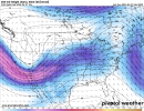
The trough would induce a strong low level response and sufficient deep layer shear. While a lot will change, focus on the synoptics. As Andy mentioned, a shortwave ejecting atop a moist boundary layer as shown by ensemble runs is trouble.
 

Timhsv

Member
Messages
432
Reaction score
773
Location
Meridianville, AL.
Special Affiliations
  1. SKYWARN® Volunteer
OHX already hinting a little:


XUS64 KOHX 201718
AFDOHX

Area Forecast Discussion
National Weather Service Nashville TN
1218 PM CDT Sat Apr 20 2024

Edited for emphasis:

For the next significant chance of rain and thunderstorms, we
have to look ahead to next weekend as a large upper-level low digs
into the southwestern US, resulting in southwesterly flow aloft
and moisture advection across Middle TN. This will set the stage
for a more active and potentially stormy pattern for next weekend.
 

jiharris0220

Member
Messages
288
Reaction score
724
Location
Wichita Falls
GEFS is consistently showing height falls in the west coast U.S /-PNA. These height falls begin on April 25, Thursday and last until at least April 30th, Tuesday. This indicates slow atmospheric angular momentum, which means the troughs that form from these height falls will be large and slow.
Which will give the atmosphere out ahead plenty of time to moisten plus destabilize, and lots of lead way to recharge. This won’t be a situation where the storms, if any should initiate, will have to catch up to the kinematics, as they will already be in place well before them.
1713666029835.png1713666050584.png
Both the GEFS and EPS show a stout trough with a potent jet streak running through the central U.S. We all have seen this tune be played before to know this kind of look leads to significant outcomes.
1713666383420.png1713666406623.png
Obviously however, the specifics are way too far out to be determined, and this could easily backtrack with the way this year has gone, but so far, by all means this smells like a classic multi day central plains severe weather outbreak.
 

jiharris0220

Member
Messages
288
Reaction score
724
Location
Wichita Falls
Would anyone consider May 2003 as a potential analog to this upcoming event and/or pattern?

BTW anyone know of a good website where I can access the past 500mb pattern for different years/months?
That is most certainly an analog, although on the most powerful roids imaginable.
And the best website I could find is this one from Columbia University. Which shows the -PNA which caused those 7 days of terror well.

1713667932029.png
https://iridl.ldeo.columbia.edu/maproom/Global/Atm_Circulation/Monthly_Height_500hPa.html?bbox=bb:-170:15:-40:75:bb&T=May 2003
 

JPWX

Member
Messages
1,511
Reaction score
4,093
Location
Smithville MS

JPWX

Member
Messages
1,511
Reaction score
4,093
Location
Smithville MS
Both the 00z and 6z GEFS continue to shows consistency for late next week thru weekend. It also shows the first disturbance that @andyhb alluded to moving thru between the 25th/26th timeframe with the BIG trough coming out between the 27th/28th.
 

Attachments

  • 500wh-mean.conus (4).png
    500wh-mean.conus (4).png
    630.4 KB · Views: 0
  • 500wh-mean.conus (3).png
    500wh-mean.conus (3).png
    625.2 KB · Views: 0
  • 500wh-mean.conus (2).png
    500wh-mean.conus (2).png
    618.8 KB · Views: 0
  • 500wh-mean.conus.png
    500wh-mean.conus.png
    627.8 KB · Views: 0

Austin Dawg

Member
Sustaining Member
Messages
871
Reaction score
1,342
Location
Leander, Texas
Looks like a lot of rain in the models the next couple weeks here in for Central Texas.The models are definitely forecasting a lot of stormy weather for this part of the country in the next couple weeks.
 
Back
Top